| Well Information Table |
|---|
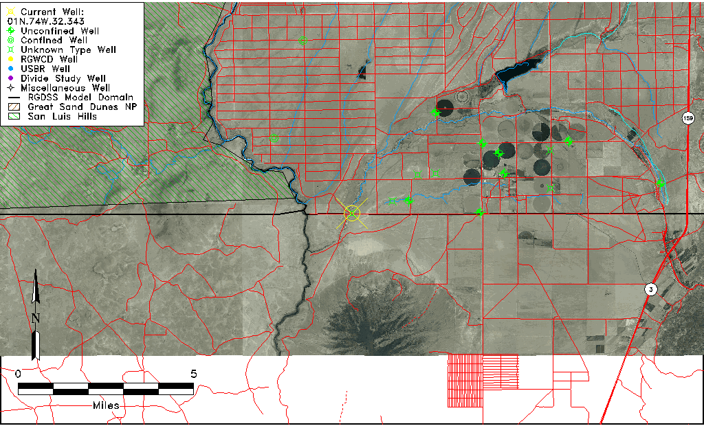
| Common Well ID | 01N.74W.32.343 |
| USGS Well ID | 365946105413901 |
| USGS Station Name | 01N.74W.32.343 |
| USGS Site Type | Well |
| USGS Site Use Information | Unknown |
| USGS Groundwater Use Information | Unknown |
| Data Source(s) | USGS |
| Location Data |
|---|
| TRS | 01N.74W.32.343 |
| USGS TRS 1 | 01N.74W.32.343 |
| USGS TRS | SWSESWS32 T01N R74W |
| Longitude/Latitude (NAD83) | -105.69416670 , 36.99611110 |
| Longitude/Latitude Data Source | GWSI decimal LAT/LONG field |
| USGS Longitude/Latitude (NAD83) | -105.6941667 , 36.99611110 |
| Easting, Northing RGDSS-NAD83 (US ft) | 194136.35 , 103.55 |
| USGS County | Costilla County |
| USGS Map Name | UTE MOUNTAIN, NM-CO |
| USGS Map Scale | 24000 |
| Elevation and Depth Data |
|---|
| Ground Elevation (ft NAVD88) | 7462.11000000000 |
| Elevation Data Source | USGS GWSI database |
| USGS Ground Elevation (ft NGVD29) | 7458.00 |
| 1/3-Arc Second NED Ground Elevation (ft NAVD88) | 7458.48 |
| 1-Arc Second NED Ground Elevation (ft NAVD88) | 7459.46 |
| SRTM Ground Elevation (ft NAVD88) | 7460.63 |
| Depth of Bottom of Layer 1 | 206 |
| Depth of Bottom of Layer 2 | 306 |
| Depth of Bottom of Layer 3 | 413 |
| Depth of Bottom of Layer 4 | 1059 |
| Additional Well Information | NONE |
| Aquifer Information |
|---|
| Aquifer Type | Unknown |
| Aquifer Type Source | None |
| USGS Hydrologic Unit | Upper Rio Grande |
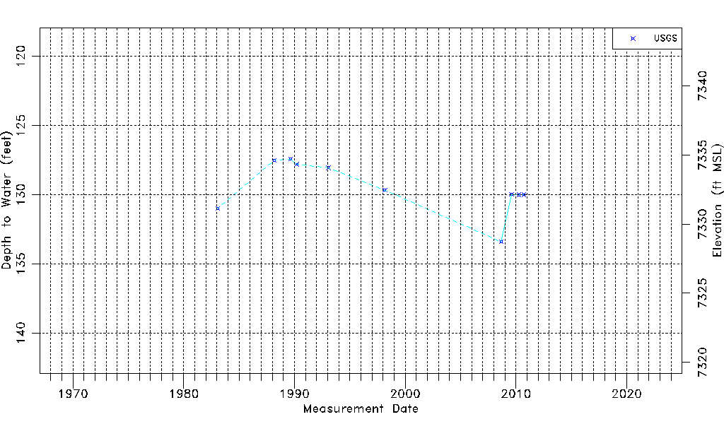
| USGS Data Available | Water-level (GW.LEV) |
| Water-level Database Information |
|---|
| Water-level Count | 10 |
| Water-level Date Range | 01/25/1983 thru 09/21/2010 |
| Monitored within the last 18 months | No, most recently on 09/21/2010 |
| Depth-to-Water Range (ft) | 127.42 to 133.40 |
| Water Table Elevation Range (ft NAVD88) | 7328.71 to 7334.69 |
| Water-Level-Source:Number-of-Measurements | USGS:10 |