| Well Information Table |
|---|
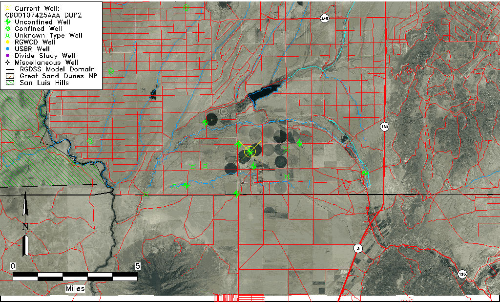
| Common Well ID | CB00107425AAA DUP2 |
| USGS Well ID | 370115105370501 |
| USGS Station Name | CB00107425AAA DUP2 |
| USGS Construction Date | 01/01/1956 |
| USGS Site Type | Well |
| USGS Site Use Information | Withdrawal of Water |
| USGS Groundwater Use Information | Irrigation |
| Data Source(s) | USGS |
| Location Data |
|---|
| TRS | CB00107425AAA DUP2 |
| USGS TRS 1 | CB00107425AAA DUP2 |
| USGS TRS | NENENES025T0001NR0074WC |
| Longitude/Latitude (NAD83) | -105.61862320 , 37.02085290 |
| Longitude/Latitude Data Source | GWSI decimal LAT/LONG field |
| USGS Longitude/Latitude (NAD83) | -105.6186232 , 37.02085290 |
| Easting, Northing RGDSS-NAD83 (US ft) | 216185.12 , 9113.79 |
| USGS County | Costilla County |
| USGS Map Name | GARCIA |
| USGS Map Scale | 24000 |
| Elevation and Depth Data |
|---|
| Ground Elevation (ft NAVD88) | 7596.17000000000 |
| Elevation Data Source | USGS GWSI database |
| USGS Ground Elevation (ft NGVD29) | 7592.00 |
| 1/3-Arc Second NED Ground Elevation (ft NAVD88) | 7582.44 |
| 1-Arc Second NED Ground Elevation (ft NAVD88) | 7581.87 |
| SRTM Ground Elevation (ft NAVD88) | 7575.59 |
| Total Depth (ft) | 284.00 |
| USGS Well Depth (ft) | 284.00 |
| Model Layer | 1 |
| Model Layer Source | Well Depth |
| Depth of Bottom of Layer 1 | 314 |
| Depth of Bottom of Layer 2 | 414 |
| Depth of Bottom of Layer 3 | 510 |
| Depth of Bottom of Layer 4 | 1108 |
| Additional Well Information | Geohydrology, Construction |
| Aquifer Information |
|---|
| Aquifer Type | Unconfined |
| Aquifer Type Source | TD Elevation/Model Layer |
| USGS Primary Aquifer | Cenozoic Erathem |
| USGS Hydrologic Unit | Upper Rio Grande |
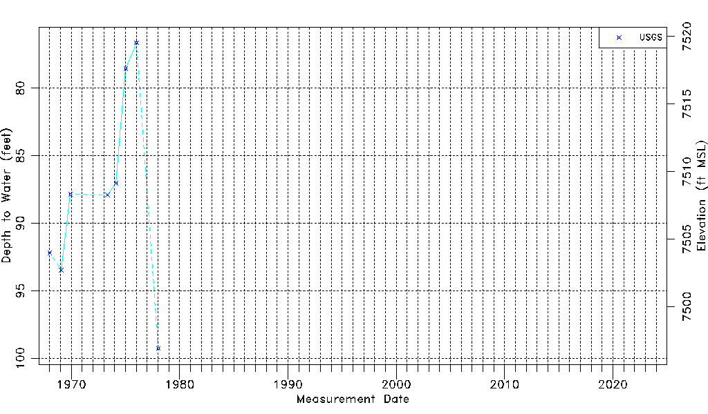
| USGS Data Available | Water-level (GW.LEV) |
| Water-level Database Information |
|---|
| Water-level Count | 8 |
| Water-level Date Range | 01/12/1968 thru 01/10/1978 |
| Monitored within the last 18 months | No, most recently on 01/10/1978 |
| Depth-to-Water Range (ft) | 76.65 to 99.28 |
| Water Table Elevation Range (ft NAVD88) | 7496.89 to 7519.52 |
| Water-Level-Source:Number-of-Measurements | USGSaguache Creek:8 |