| Well Information Table |
|---|
| Common Well ID | NA03300928ADD |
| USGS Well ID | 370420105585801 |
| USGS Station Name | NA03300928ADD |
| USGS Site Type | Well |
| USGS Site Use Information | Observation |
| USGS Groundwater Use Information | Irrigation |
| Data Source(s) | USGS |
| Location Data |
|---|
| TRS | NA03300928ADD |
| USGS TRS 1 | NA03300928ADD |
| Longitude/Latitude (NAD83) | -105.98335440 , 37.07223506 |
| Longitude/Latitude Data Source | GWSI decimal LAT/LONG field |
| USGS Longitude/Latitude (NAD83) | -105.9833544 , 37.07223506 |
| Easting, Northing RGDSS-NAD83 (US ft) | 109797.03 , 27954.24 |
| USGS Topography | Valley flat |
| USGS County | Conejos County |
| USGS Map Name | LOBATOS, CO. |
| USGS Map Scale | 24000 |
| Elevation and Depth Data |
|---|
| Ground Elevation (ft NAVD88) | 7847.06000000000 |
| Elevation Data Source | USGS GWSI database |
| USGS Ground Elevation (ft NGVD29) | 7843.00 |
| 1/3-Arc Second NED Ground Elevation (ft NAVD88) | 7846.22 |
| 1-Arc Second NED Ground Elevation (ft NAVD88) | 7847.06 |
| SRTM Ground Elevation (ft NAVD88) | 7854.19 |
| Depth of Bottom of Layer 1 | 35 |
| Depth of Bottom of Layer 2 | 127 |
| Depth of Bottom of Layer 3 | 263 |
| Depth of Bottom of Layer 4 | 1532 |
| Additional Well Information | NONE |
| Aquifer Information |
|---|
| Aquifer Type | Unknown |
| Aquifer Type Source | None |
| USGS Hydrologic Unit | Conejos |
| USGS Data Available | Water-level (GW.LEV) |
| Water-level Database Information |
|---|
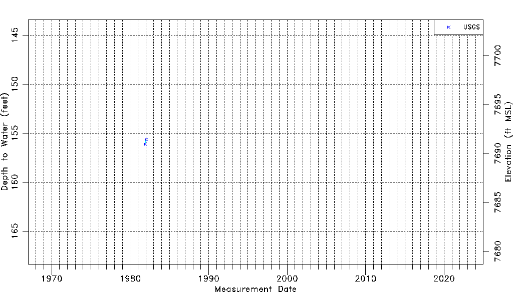
| Water-level Count | 2 |
| Water-level Date Range | 12/03/1981 thru 01/22/1982 |
| Monitored within the last 18 months | No, most recently on 01/22/1982 |
| Depth-to-Water Range (ft) | 155.63 to 156.13 |
| Water Table Elevation Range (ft NAVD88) | 7690.93 to 7691.43 |
| Water-Level-Source:Number-of-Measurements | USGSaguache Creek:2 |