| Well Information Table |
|---|
| Common Well ID | CB00307324ACA |
| USGS Well ID | 371237105303201 |
| USGS Station Name | CB00307324ACA |
| USGS Site Type | Well |
| USGS Site Use Information | Withdrawal of Water |
| USGS Groundwater Use Information | Irrigation |
| Data Source(s) | USGS |
| Location Data |
|---|
| TRS | CB00307324ACA |
| USGS TRS 1 | CB00307324ACA |
| USGS TRS | NESWNES024T0003NR0073WC |
| Longitude/Latitude (NAD83) | -105.50840160 , 37.20845868 |
| Longitude/Latitude Data Source | GWSI decimal LAT/LONG field |
| USGS Longitude/Latitude (NAD83) | -105.5084016 , 37.20845868 |
| Easting, Northing RGDSS-NAD83 (US ft) | 248232.00 , 77435.12 |
| USGS County | Costilla County |
| Elevation and Depth Data |
|---|
| Ground Elevation (ft NAVD88) | 7793.25000000000 |
| Elevation Data Source | USGS GWSI database |
| USGS Ground Elevation (ft NGVD29) | 7789.00 |
| 1/3-Arc Second NED Ground Elevation (ft NAVD88) | 7795.07 |
| 1-Arc Second NED Ground Elevation (ft NAVD88) | 7795.03 |
| SRTM Ground Elevation (ft NAVD88) | 7794.91 |
| Total Depth (ft) | 300.00 |
| USGS Well Depth (ft) | 300.00 |
| Model Layer | 2 |
| Model Layer Source | Well Depth |
| Depth of Bottom of Layer 1 | 264 |
| Depth of Bottom of Layer 2 | 369 |
| Depth of Bottom of Layer 3 | 777 |
| Depth of Bottom of Layer 4 | 1321 |
| Additional Well Information | Geohydrology, Construction |
| Aquifer Information |
|---|
| Aquifer Type | Confined |
| Aquifer Type Source | TD Elevation/Model Layer |
| USGS Primary Aquifer | Cenozoic Erathem |
| USGS Aquifer Type | Unconfined Single Aquifer |
| USGS Hydrologic Unit | Alamosa-Trinchera |
| USGS Data Available | Water-level (GW.LEV) |
| Water-level Database Information |
|---|
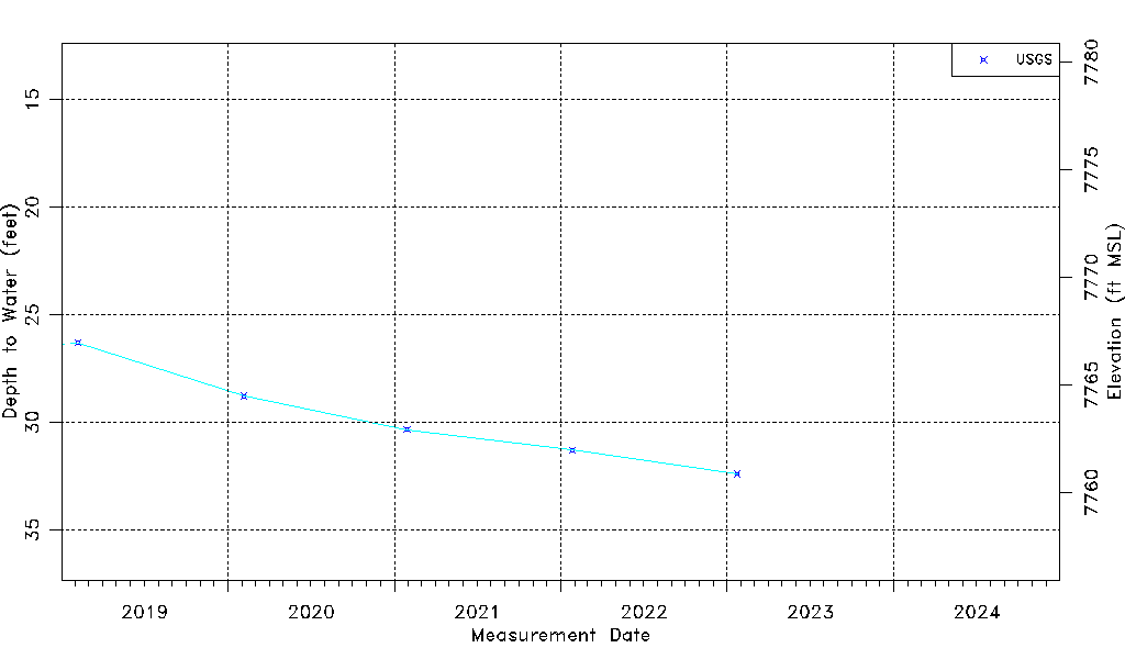
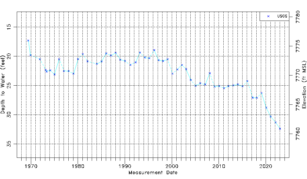
| Water-level Count | 54 |
| Water-level Date Range | 06/04/1969 thru 01/23/2023 |
| Monitored within the last 18 months | Yes, most recently on 01/23/2023 |
| Depth-to-Water Range (ft) | 17.30 to 32.40 |
| Water Table Elevation Range (ft NAVD88) | 7760.85 to 7775.95 |
| Water-Level-Source:Number-of-Measurements | USGS:54 |