| Well Information Table |
|---|
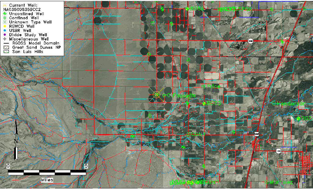
| Common Well ID | NA03600835BCC2 |
| USGS Well ID | 371914106042902 |
| USGS Station Name | NA03600835BCC2 |
| USGS Construction Date | 11/05/2006 |
| USGS Site Type | Well |
| USGS Site Use Information | Unknown |
| USGS Groundwater Use Information | Unknown |
| Data Source(s) | USGS |
| Location Data |
|---|
| TRS | NA03600835BCC2 |
| USGS TRS 1 | NA03600835BCC2 |
| USGS TRS | SWSWNWS35 T36N R8E N |
| Longitude/Latitude (NAD83) | -106.07488330 , 37.32070556 |
| Longitude/Latitude Data Source | GWSI decimal LAT/LONG field |
| USGS Longitude/Latitude (NAD83) | -106.0748833 , 37.32070556 |
| Easting, Northing RGDSS-NAD83 (US ft) | 83482.73 , 118497.23 |
| USGS County | Conejos County |
| USGS Map Name | CAPULIN |
| USGS Map Scale | 24000 |
| Elevation and Depth Data |
|---|
| Ground Elevation (ft NAVD88) | 7739.00000000000 |
| Elevation Data Source | USGS GWSI database |
| USGS Ground Elevation (ft NAVD88) | 7739.00 |
| 1/3-Arc Second NED Ground Elevation (ft NAVD88) | 7737.90 |
| 1-Arc Second NED Ground Elevation (ft NAVD88) | 7737.41 |
| SRTM Ground Elevation (ft NAVD88) | 7732.20 |
| Total Depth (ft) | 54.70 |
| USGS Hole Depth (ft) | 55.00 |
| USGS Well Depth (ft) | 54.70 |
| Model Layer | 2 |
| Model Layer Source | Well Depth |
| Depth of Bottom of Layer 1 | 27 |
| Depth of Bottom of Layer 2 | 221 |
| Depth of Bottom of Layer 3 | 285 |
| Depth of Bottom of Layer 4 | 1409 |
| Additional Well Information | NONE |
| Aquifer Information |
|---|
| Aquifer Type | Confined |
| Aquifer Type Source | TD Elevation/Model Layer |
| USGS Primary Aquifer | 112ALMS |
| USGS Hydrologic Unit | Alamosa-Trinchera |
| USGS Data Available | Geohydrologic |
| Water-level Database Information |
|---|
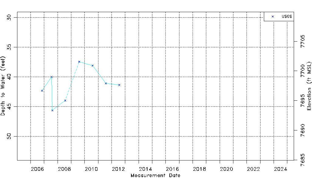
| Water-level Count | 8 |
| Water-level Date Range | 11/05/2006 thru 07/27/2012 |
| Monitored within the last 18 months | No, most recently on 07/27/2012 |
| Depth-to-Water Range (ft) | 37.45 to 45.64 |
| Water Table Elevation Range (ft NAVD88) | 7693.36 to 7701.55 |
| Water-Level-Source:Number-of-Measurements | USGS:8 |