| Well Information Table |
|---|
| Common Well ID | NA03600803DAC |
| USGS Well ID | 372315106044501 |
| USGS Station Name | NA03600803DAC |
| USGS Construction Date | 01/01/1954 |
| USGS Site Type | Well |
| USGS Site Use Information | Withdrawal of Water |
| USGS Groundwater Use Information | Irrigation |
| Data Source(s) | USGS |
| Location Data |
|---|
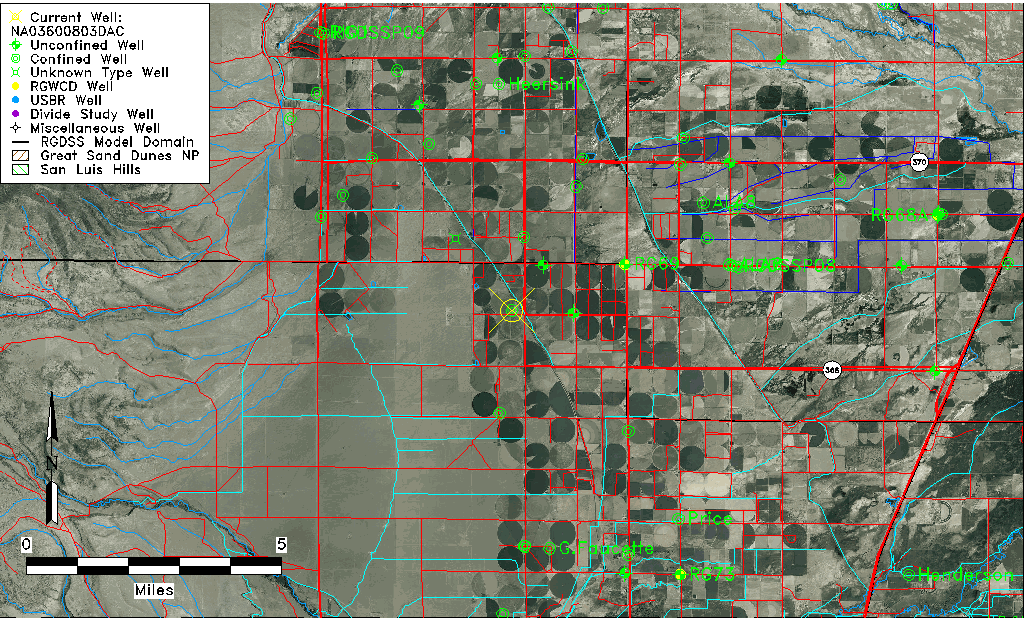
| TRS | NA03600803DAC |
| USGS TRS 1 | NA03600803DAC |
| USGS TRS | SWNESES003T0036NR0008EN |
| Longitude/Latitude (NAD83) | -106.07974900 , 37.38750554 |
| Longitude/Latitude Data Source | GWSI decimal LAT/LONG field |
| USGS Longitude/Latitude (NAD83) | -106.0797490 , 37.38750554 |
| Easting, Northing RGDSS-NAD83 (US ft) | 82173.07 , 142819.34 |
| USGS County | Conejos County |
| Elevation and Depth Data |
|---|
| Ground Elevation (ft NAVD88) | 7684.26000000000 |
| Elevation Data Source | USGS GWSI database |
| USGS Ground Elevation (ft NGVD29) | 7680.00 |
| 1/3-Arc Second NED Ground Elevation (ft NAVD88) | 7690.05 |
| 1-Arc Second NED Ground Elevation (ft NAVD88) | 7689.81 |
| SRTM Ground Elevation (ft NAVD88) | 7690.61 |
| Total Depth (ft) | 75.00 |
| USGS Well Depth (ft) | 75.00 |
| Model Layer | 2 |
| Model Layer Source | Well Depth |
| Depth of Bottom of Layer 1 | 56 |
| Depth of Bottom of Layer 2 | 165 |
| Depth of Bottom of Layer 3 | 316 |
| Depth of Bottom of Layer 4 | 1900 |
| Additional Well Information | Geohydrology, Construction |
| Aquifer Information |
|---|
| Aquifer Type | Confined |
| Aquifer Type Source | TD Elevation/Model Layer |
| USGS Primary Aquifer | Cenozoic Erathem |
| USGS Hydrologic Unit | Alamosa-Trinchera |
| USGS Data Available | Water-level (GW.LEV) |
| Water-level Database Information |
|---|
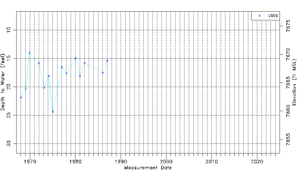
| Water-level Count | 14 |
| Water-level Date Range | 01/16/1968 thru 01/21/1987 |
| Monitored within the last 18 months | No, most recently on 01/21/1987 |
| Depth-to-Water Range (ft) | 14.00 to 24.40 |
| Water Table Elevation Range (ft NAVD88) | 7659.86 to 7670.26 |
| Water-Level-Source:Number-of-Measurements | USGS:14 |