Well NA03901224CCC2 EW-76U (EW76U)
Unconfined

Co-located Well(s):
NA03901224CCC EW-76C (EW76C)

Home | Well Information | Hydrograph | Water Level Data Table
RGWCD Unconfined Wells:MapList
RGWCD Confined Wells:MapList
Baca Grant Wells:MapList
Divide Study Wells:MapList
Upper Rio Grande Wells:MapList
CWCD Wells:MapList
USBR Wells:MapList
USGS Wells:MapList
Dunes Hydro Study Wells:MapList
GSDNP Boundary Wells:MapList
Recently Monitored Wells:MapList
Unconfined Wells:MapList
Confined Wells:MapList

Index Map showing
model domain.

Green shaded area
enlarged below.

Click on map
to quickly move to
another location.


View Digital Orthophoto Quadrangle for this area

Well Information Table
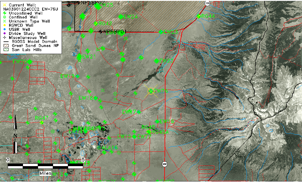
Common Well IDNA03901224CCC2 EW-76U
USBR Well IDEW76U
USGS Well ID373621105370302
USGS Station NameNA03901224CCC2 EW-76U
USGS Construction Date12/14/1977
USGS Site TypeWell
USGS Site Use InformationObservation
USGS Groundwater Use InformationUnknown
Data Source(s)USGS, USBR
Location Data
TRSNA03901224CCC2 EW-76U
USBR TRSNA03901224CCC2
USGS TRS 1NA03901224CCC2 EW-76U
Longitude/Latitude (NAD83)-105.61811582 , 37.60590133
Longitude/Latitude Data SourceUSBOR EW well locations
USGS Longitude/Latitude (NAD83)-105.6180705 , 37.60583668
USBR Longitude/Latitude (NAD27)-105.617545325487 , 37.6058979827788
Easting, Northing RGDSS-NAD83 (US ft)216209.14 , 222063.44
USGS TopographyValley flat
USGS CountyAlamosa County
USGS Map NameTWIN PEAKS
USGS Map Scale24000
Elevation and Depth Data
Ground Elevation (ft NAVD88)7615.33000000000
Elevation Data SourceUSBOR EW well database
USBR Ground Elevation (ft NGVD29)7611.1
USGS Ground Elevation (ft NGVD29)7611.10
1/3-Arc Second NED Ground Elevation (ft NAVD88)7615.02
1-Arc Second NED Ground Elevation (ft NAVD88)7615.67
SRTM Ground Elevation (ft NAVD88)7623.00
Total Depth (ft)18.00
USBR Total Depth (ft)18
USGS Hole Depth (ft)12.62
USGS Well Depth (ft)12.62
Model Layer1
Model Layer SourceAquifer Type
Depth of Bottom of Layer 1139
Depth of Bottom of Layer 2549
Depth of Bottom of Layer 31010
Depth of Bottom of Layer 42267
Additional Well InformationConstruction
Aquifer Information
Aquifer TypeUnconfined
Aquifer Type SourceEW_AQFR
USGS Hydrologic UnitSan Luis
USGS Data AvailableWater-level (GW.LEV)
Water-level Database Information
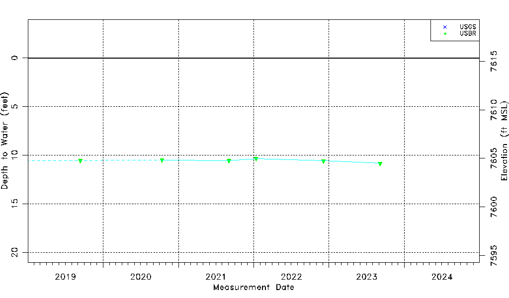
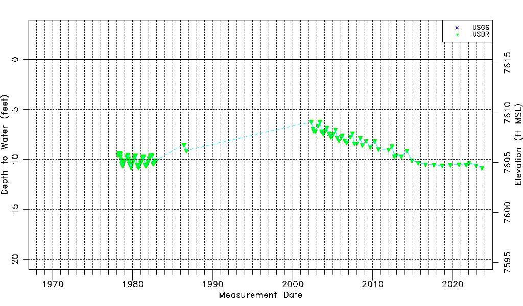
Water-level Count118
Water-level Date Range02/18/1978 thru 09/05/2023
Monitored within the last 18 monthsYes, most recently on 09/05/2023
Depth-to-Water Range (ft)6.23 to 10.83
Water Table Elevation Range (ft NAVD88)7604.50 to 7609.10
Water-Level-Source:Number-of-MeasurementsUSGS:6 USBR:116

Top of Page


Water-level Data

2019 to Present

1967 to Present

Top of Page


Measurement DateDepth to
Water (ft)
Elevation
(ft NAVD88)
Data
Source(s)
02/18/19789.507605.83USBR
03/23/19789.407605.93USBR
04/07/19789.407605.93USBR
04/21/19789.307606.03USBR
05/10/19789.307606.03USBR
05/26/19789.307606.03USBR
06/09/19789.407605.93USBR
06/23/19789.707605.63USBR
07/11/197810.007605.33USBR
08/10/197810.407604.93USBR
08/25/197810.507604.83USBR
09/07/197810.607604.73USBR
09/22/197810.607604.73USBR
10/06/197810.607604.73USBR
10/20/197810.507604.83USBR
11/07/197810.407604.93USBR
11/17/197810.307605.03USBR
12/01/197810.307605.03USBR
12/15/197810.207605.13USBR
01/04/197910.107605.23USBR
04/04/19799.707605.63USBR
04/20/19799.707605.63USBR
05/09/19799.707605.63USBR
05/18/19799.607605.73USBR
06/04/19799.607605.73USBR
06/15/19799.507605.83USBR
07/02/19799.907605.43USBR
07/18/197910.207605.13USBR
07/25/197910.257605.08USGS
07/28/197910.407604.93USBR
10/15/197910.807604.53USBR
11/15/197910.407604.93USBR
12/15/197910.407604.93USBR
01/15/198010.107605.23USBR
02/15/198010.107605.23USBR
03/15/19809.907605.43USBR
04/15/19809.707605.63USBR
05/15/19809.607605.73USBR
07/15/198010.507604.83USBR
08/15/198010.707604.63USBR
09/15/198010.807604.53USBR
10/15/198010.707604.63USBR
11/15/198010.507604.83USBR
12/15/198010.307605.03USBR
01/15/198110.207605.13USBR
02/15/198110.107605.23USBR
03/15/19819.807605.53USBR
05/04/19819.707605.63USBR
06/02/19819.707605.63USBR
07/15/198110.507604.83USBR
08/15/198110.607604.73USBR
09/15/198110.607604.73USBR
10/15/198110.507604.83USBR
11/15/198110.407604.93USBR
12/15/198110.207605.13USBR
01/15/19829.907605.43USBR
03/15/19829.707605.63USBR
04/15/19829.507605.83USBR
05/15/19829.507605.83USBR
06/15/19829.607605.73USBR
07/15/198210.407604.93USBR
08/15/198210.407604.93USBR
09/15/198210.307605.03USBR
10/15/198210.207605.13USBR
11/15/198210.107605.23USBR
12/15/198210.107605.23USBR
05/15/19868.507606.83USBR
06/15/19868.507606.83USBR
09/15/19869.107606.23USBR
04/29/20026.237609.10USBR
07/23/20026.947608.39USBR
08/14/20027.137608.20USBR
10/29/20027.167608.17USBR
02/21/20036.607608.73USGS,USBR
05/30/20036.237609.10USBR
08/07/20037.187608.15USGS,USBR
10/23/20037.447607.89USBR
01/15/20047.107608.23USGS,USBR
03/26/20046.807608.53USBR
07/08/20047.377607.96USBR
07/21/20047.487607.85USGS
09/29/20047.757607.58USBR
12/02/20047.657607.68USBR
01/25/20057.447607.89USBR
05/11/20057.027608.31USBR
07/26/20057.847607.49USGS,USBR
10/13/20058.097607.24USBR
01/27/20067.757607.58USBR
03/14/20067.577607.76USBR
07/06/20068.077607.26USBR
09/25/20068.297607.04USBR
03/15/20077.757607.58USBR
06/15/20077.397607.94USBR
09/15/20078.407606.93USBR
01/14/20088.397606.94USBR
06/12/20087.837607.50USBR
09/17/20088.567606.77USBR
03/04/20098.137607.20USBR
09/09/20098.747606.59USBR
03/26/20108.167607.17USBR
09/15/20108.957606.38USBR
12/27/20119.007606.33USBR
05/29/20128.687606.65USBR
09/15/20129.707605.63USBR
12/04/20129.577605.76USBR
07/31/20139.707605.63USBR
04/16/20149.137606.20USBR
11/25/201410.097605.24USBR
08/31/201510.327605.01USBR
08/03/201610.477604.86USBR
09/06/201710.547604.79USBR
09/06/201810.607604.73USBR
09/12/201910.557604.78USBR
10/13/202010.497604.84USBR
09/02/202110.547604.79USBR
01/12/202210.347604.99USBR
12/05/202210.587604.75USBR
09/05/202310.837604.50USBR

Top of Page