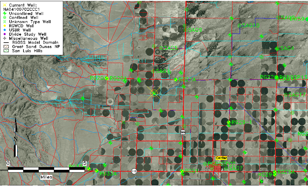
| Well Information Table |
|---|
| Common Well ID | NA04100702CCC1 |
| USGS Well ID | 374920106105501 |
| USGS Station Name | NA04100702CCC1 |
| USGS Site Type | Well |
| USGS Site Use Information | Withdrawal of Water |
| USGS Groundwater Use Information | Irrigation |
| Data Source(s) | USGS |
| Location Data |
|---|
| TRS | NA04100702CCC1 |
| USGS TRS 1 | NA04100702CCC1 |
| USGS TRS | SWSWSWS002T0041NR0007EN |
| Longitude/Latitude (NAD83) | -106.18252800 , 37.82222330 |
| Longitude/Latitude Data Source | GWSI decimal LAT/LONG field |
| USGS Longitude/Latitude (NAD83) | -106.1825280 , 37.82222330 |
| Easting, Northing RGDSS-NAD83 (US ft) | 53186.02 , 301216.75 |
| USGS Topography | Valley flat |
| USGS County | Saguache County |
| Elevation and Depth Data |
|---|
| Ground Elevation (ft NAVD88) | 7658.63000000000 |
| Elevation Data Source | USGS GWSI database |
| USGS Ground Elevation (ft NGVD29) | 7654.00 |
| 1/3-Arc Second NED Ground Elevation (ft NAVD88) | 7656.98 |
| 1-Arc Second NED Ground Elevation (ft NAVD88) | 7656.98 |
| SRTM Ground Elevation (ft NAVD88) | 7660.07 |
| Total Depth (ft) | 76.00 |
| USGS Well Depth (ft) | 76.00 |
| Model Layer | 1 |
| Model Layer Source | Well Depth |
| Depth of Bottom of Layer 1 | 128 |
| Depth of Bottom of Layer 2 | 272 |
| Depth of Bottom of Layer 3 | 452 |
| Depth of Bottom of Layer 4 | 1799 |
| Additional Well Information | Geohydrology, Construction |
| Aquifer Information |
|---|
| Aquifer Type | Unconfined |
| Aquifer Type Source | TD Elevation/Model Layer |
| USGS Primary Aquifer | Cenozoic Erathem |
| USGS Hydrologic Unit | Saguache |
| USGS Data Available | Water-level (GW.LEV) |
| Water-level Database Information |
|---|
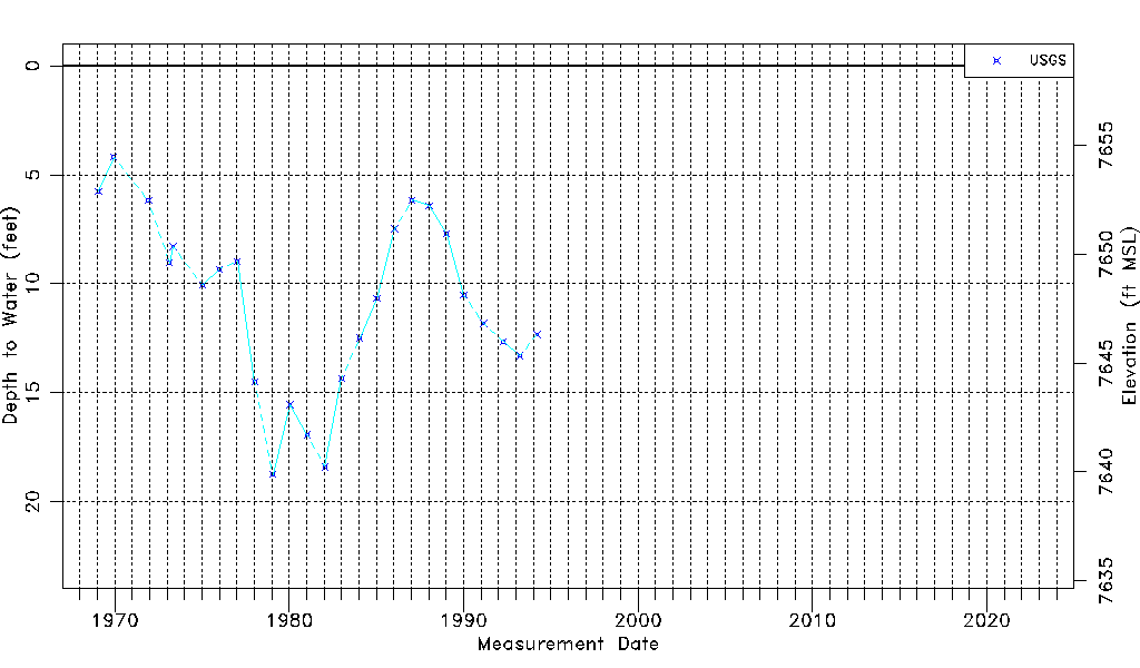
| Water-level Count | 25 |
| Water-level Date Range | 01/28/1969 thru 03/24/1994 |
| Monitored within the last 18 months | No, most recently on 03/24/1994 |
| Depth-to-Water Range (ft) | 4.19 to 18.75 |
| Water Table Elevation Range (ft NAVD88) | 7639.88 to 7654.44 |
| Water-Level-Source:Number-of-Measurements | USGS:25 |