| Well Information Table |
|---|
| Common Well ID | NA04300905DDD |
| USGS Well ID | 375940106000001 |
| USGS Station Name | NA04300905DDD |
| USGS Construction Date | 01/01/1946 |
| USGS Site Type | Well |
| USGS Site Use Information | Observation |
| USGS Groundwater Use Information | Unused |
| Data Source(s) | USGS |
| Location Data |
|---|
| TRS | NA04300905DDD |
| USGS TRS 1 | NA04300905DDD |
| USGS TRS | SESESES005T0043NR0009EN |
| Longitude/Latitude (NAD83) | -105.99746220 , 37.99374949 |
| Longitude/Latitude Data Source | GWSI decimal LAT/LONG field |
| USGS Longitude/Latitude (NAD83) | -105.9974622 , 37.99374949 |
| Easting, Northing RGDSS-NAD83 (US ft) | 106851.07 , 363416.57 |
| USGS Topography | Valley flat |
| USGS County | Saguache County |
| Elevation and Depth Data |
|---|
| Ground Elevation (ft NAVD88) | 7575.12000000000 |
| Elevation Data Source | USGS GWSI database |
| USGS Ground Elevation (ft NGVD29) | 7571.00 |
| 1/3-Arc Second NED Ground Elevation (ft NAVD88) | 7574.44 |
| 1-Arc Second NED Ground Elevation (ft NAVD88) | 7575.25 |
| SRTM Ground Elevation (ft NAVD88) | 7578.74 |
| Total Depth (ft) | 10.00 |
| USGS Well Depth (ft) | 10.00 |
| Model Layer | 1 |
| Model Layer Source | Well Depth |
| Depth of Bottom of Layer 1 | 105 |
| Depth of Bottom of Layer 2 | 252 |
| Depth of Bottom of Layer 3 | 710 |
| Depth of Bottom of Layer 4 | 2573 |
| Additional Well Information | Geohydrology, Construction |
| Aquifer Information |
|---|
| Aquifer Type | Unconfined |
| Aquifer Type Source | TD Elevation/Model Layer |
| USGS Primary Aquifer | Cenozoic Erathem |
| USGS Aquifer Type | Unconfined Single Aquifer |
| USGS Hydrologic Unit | Saguache |
| USGS Data Available | Water-level (GW.LEV) |
| Water-level Database Information |
|---|
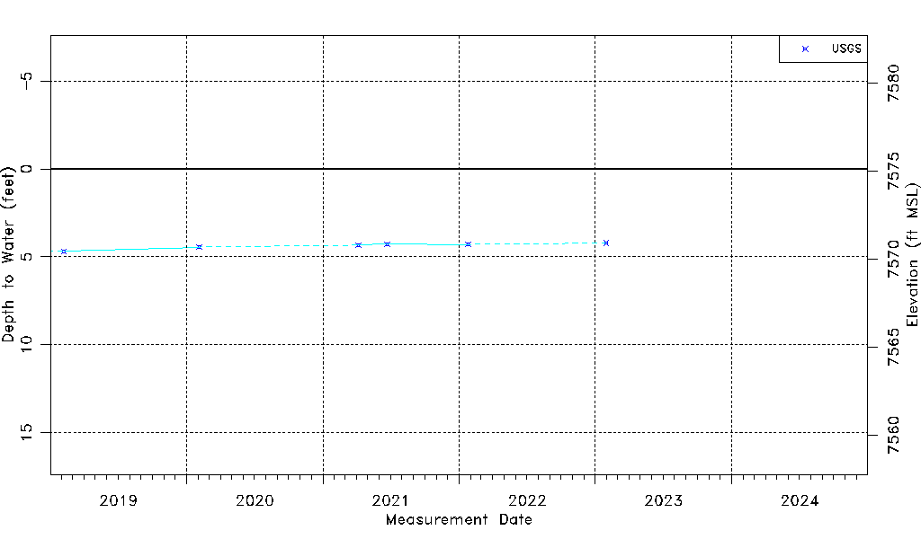
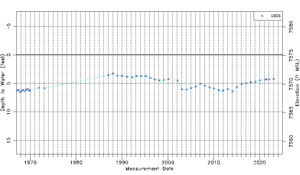
| Water-level Count | 52 |
| Water-level Date Range | 01/04/1967 thru 01/30/2023 |
| Monitored within the last 18 months | Yes, most recently on 01/30/2023 |
| Depth-to-Water Range (ft) | 3.25 to 6.52 |
| Water Table Elevation Range (ft NAVD88) | 7568.60 to 7571.87 |
| Water-Level-Source:Number-of-Measurements | USGS:52 |