| Well Information Table |
|---|
| Common Well ID | DUN32 |
| GSDNP Well Name | 32 |
| USGS Site Use Information | Unknown |
| USGS Groundwater Use Information | Unknown |
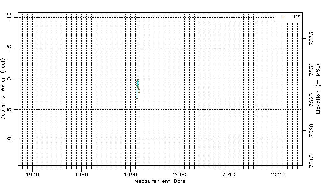
| Data Source(s) | HRS |
| Location Data |
|---|
| Longitude/Latitude (NAD83) | -105.73147836 , 37.71048648 |
| Longitude/Latitude Data Source | HRS Dunes database |
| Easting, Northing RGDSS-NAD83 (US ft) | 183405.65 , 260135.90 |
| Elevation and Depth Data |
|---|
| Ground Elevation (ft NAVD88) | 7528.43000000000 |
| Elevation Data Source | CSU well databse |
| CSU Dunes Well database (ft NGVD29) | 7524.36 |
| HRS Dunes Well database (ft NGVD29) | 7524.35986 |
| 1/3-Arc Second NED Ground Elevation (ft NAVD88) | 7531.59 |
| 1-Arc Second NED Ground Elevation (ft NAVD88) | 7530.89 |
| SRTM Ground Elevation (ft NAVD88) | 7533.62 |
| Model Layer | 1 |
| Model Layer Source | Aquifer Type |
| Depth of Bottom of Layer 1 | 132 |
| Depth of Bottom of Layer 2 | 425 |
| Depth of Bottom of Layer 3 | 1618 |
| Depth of Bottom of Layer 4 | 3283 |
| Additional Well Information | NONE |
| Aquifer Information |
|---|
| Aquifer Type | Unconfined |
| Aquifer Type Source | HRS_AQUIFER |
| Water-level Database Information |
|---|
| Water-level Count | 22 |
| Water-level Date Range | 04/30/1991 thru 10/14/1991 |
| Monitored within the last 18 months | No, most recently on 10/14/1991 |
| Depth-to-Water Range (ft) | 0.09 to 3.20 |
| Water Table Elevation Range (ft NAVD88) | 7525.23 to 7528.34 |
| Water-Level-Source:Number-of-Measurements | HRSaguache Creek:22 |