| Well Information Table |
|---|
| Common Well ID | DUN54 |
| GSDNP Well Name | 54 |
| USGS Site Use Information | Unknown |
| USGS Groundwater Use Information | Unknown |
| Data Source(s) | HRS |
| Location Data |
|---|
| Longitude/Latitude (NAD83) | -105.73275406 , 37.68677386 |
| Longitude/Latitude Data Source | HRS Dunes database |
| Easting, Northing RGDSS-NAD83 (US ft) | 183030.69 , 251504.40 |
| Elevation and Depth Data |
|---|
| Ground Elevation (ft NAVD88) | 7523.14000000000 |
| Elevation Data Source | CSU well databse |
| CSU Dunes Well database (ft NGVD29) | 7519.09 |
| HRS Dunes Well database (ft NGVD29) | 7519.08984 |
| 1/3-Arc Second NED Ground Elevation (ft NAVD88) | 7525.10 |
| 1-Arc Second NED Ground Elevation (ft NAVD88) | 7521.51 |
| SRTM Ground Elevation (ft NAVD88) | 7544.36 |
| Model Layer | 1 |
| Model Layer Source | Aquifer Type |
| Depth of Bottom of Layer 1 | 135 |
| Depth of Bottom of Layer 2 | 450 |
| Depth of Bottom of Layer 3 | 1634 |
| Depth of Bottom of Layer 4 | 3311 |
| Additional Well Information | NONE |
| Aquifer Information |
|---|
| Aquifer Type | Unconfined |
| Aquifer Type Source | HRS_AQUIFER |
| Water-level Database Information |
|---|
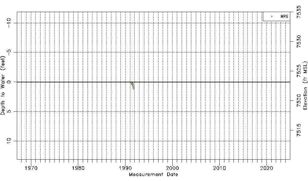
| Water-level Count | 21 |
| Water-level Date Range | 04/30/1991 thru 10/14/1991 |
| Monitored within the last 18 months | No, most recently on 10/14/1991 |
| Depth-to-Water Range (ft) | 0.05 to 1.17 |
| Water Table Elevation Range (ft NAVD88) | 7521.97 to 7523.09 |
| Water-Level-Source:Number-of-Measurements | HRSaguache Creek:21 |