| Well Information Table |
|---|
| Common Well ID | DUNBMPW1 |
| GSDNP Well Name | BMPW-1 |
| USGS Site Use Information | Unknown |
| USGS Groundwater Use Information | Unknown |
| Data Source(s) | HRS |
| Location Data |
|---|
| Longitude/Latitude (NAD83) | -105.88804774 , 37.91927727 |
| Longitude/Latitude Data Source | BACA wells reported by Halepaska |
| Halapaska & Assoc. Easting/Northing (CO-S) | 1888225.00000000 , 456323.000000000 |
| Easting, Northing RGDSS-NAD83 (US ft) | 138307.55 , 336211.00 |
| Elevation and Depth Data |
|---|
| Ground Elevation (ft NAVD88) | 7543.85000000000 |
| Elevation Data Source | BACA well (HRS from topo) |
| BACA Well database (HRS, ft NGVD29) | 7540 |
| HRS Dunes Well database (ft NGVD29) | 7540.00000 |
| 1/3-Arc Second NED Ground Elevation (ft NAVD88) | 7543.95 |
| 1-Arc Second NED Ground Elevation (ft NAVD88) | 7543.31 |
| SRTM Ground Elevation (ft NAVD88) | 7558.20 |
| Total Depth (ft) | 8.50 |
| Model Layer | 1 |
| Model Layer Source | Dunes Layer |
| Depth of Bottom of Layer 1 | 65 |
| Depth of Bottom of Layer 2 | 152 |
| Depth of Bottom of Layer 3 | 883 |
| Depth of Bottom of Layer 4 | 3738 |
| Additional Well Information | NONE |
| Aquifer Information |
|---|
| Aquifer Type | Unconfined |
| Aquifer Type Source | HRS_AQUIFER |
| Water-level Database Information |
|---|
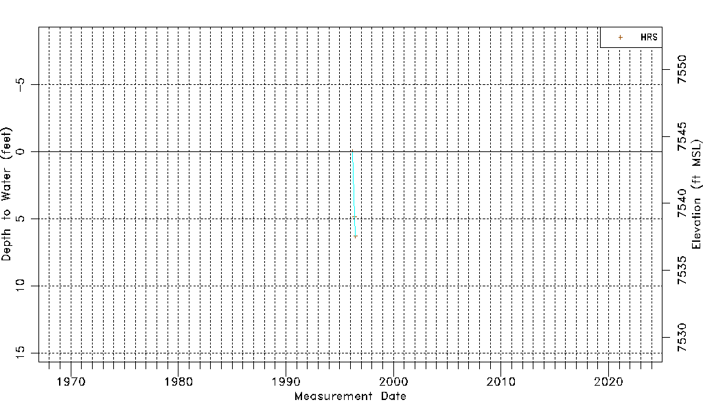
| Water-level Count | 3 |
| Water-level Date Range | 03/14/1996 thru 06/25/1996 |
| Monitored within the last 18 months | No, most recently on 06/25/1996 |
| Depth-to-Water Range (ft) | 0.00 to 6.29 |
| Water Table Elevation Range (ft NAVD88) | 7537.56 to 7543.85 |
| Water-Level-Source:Number-of-Measurements | HRS:3 |