| Well Information Table |
|---|
| Common Well ID | DUNSW11 |
| GSDNP Well Name | SW-11 |
| USGS Site Use Information | Unknown |
| USGS Groundwater Use Information | Unknown |
| Data Source(s) | HRS |
| Location Data |
|---|
| Longitude/Latitude (NAD83) | -105.78080157 , 37.88007804 |
| Longitude/Latitude Data Source | BACA wells reported by Halepaska |
| Halapaska & Assoc. Easting/Northing (CO-S) | 1919119.00000000 , 441939.000000000 |
| Easting, Northing RGDSS-NAD83 (US ft) | 169217.64 , 321884.77 |
| Elevation and Depth Data |
|---|
| Ground Elevation (ft NAVD88) | 7560.09000000000 |
| Elevation Data Source | BACA well (Halepaska) |
| BACA Well database (Halapaska & Assoc, ft NGVD29) | 7556 |
| HRS Dunes Well database (ft NGVD29) | 7556.00000 |
| 1/3-Arc Second NED Ground Elevation (ft NAVD88) | 7559.48 |
| 1-Arc Second NED Ground Elevation (ft NAVD88) | 7560.68 |
| SRTM Ground Elevation (ft NAVD88) | 7567.71 |
| Total Depth (ft) | 161.00 |
| Model Layer | 1 |
| Model Layer Source | Dunes Layer |
| Depth of Bottom of Layer 1 | 161 |
| Depth of Bottom of Layer 2 | 425 |
| Depth of Bottom of Layer 3 | 1669 |
| Depth of Bottom of Layer 4 | 4566 |
| Additional Well Information | NONE |
| Aquifer Information |
|---|
| Aquifer Type | Unconfined |
| Aquifer Type Source | HRS_AQUIFER |
| Water-level Database Information |
|---|
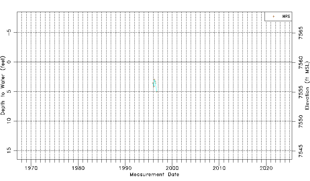
| Water-level Count | 6 |
| Water-level Date Range | 11/28/1995 thru 09/18/1996 |
| Monitored within the last 18 months | No, most recently on 09/18/1996 |
| Depth-to-Water Range (ft) | 3.00 to 5.00 |
| Water Table Elevation Range (ft NAVD88) | 7555.09 to 7557.09 |
| Water-Level-Source:Number-of-Measurements | HRSaguache Creek:6 |