Well SCS04
Unconfined


Home | Well Information | Hydrograph | Water Level Data Table
RGWCD Unconfined Wells:MapList
RGWCD Confined Wells:MapList
Baca Grant Wells:MapList
Divide Study Wells:MapList
Upper Rio Grande Wells:MapList
CWCD Wells:MapList
USBR Wells:MapList
USGS Wells:MapList
Dunes Hydro Study Wells:MapList
GSDNP Boundary Wells:MapList
Recently Monitored Wells:MapList
Unconfined Wells:MapList
Confined Wells:MapList

Index Map showing
model domain.

Green shaded area
enlarged below.

Click on map
to quickly move to
another location.


View Digital Orthophoto Quadrangle for this area

Well Information Table
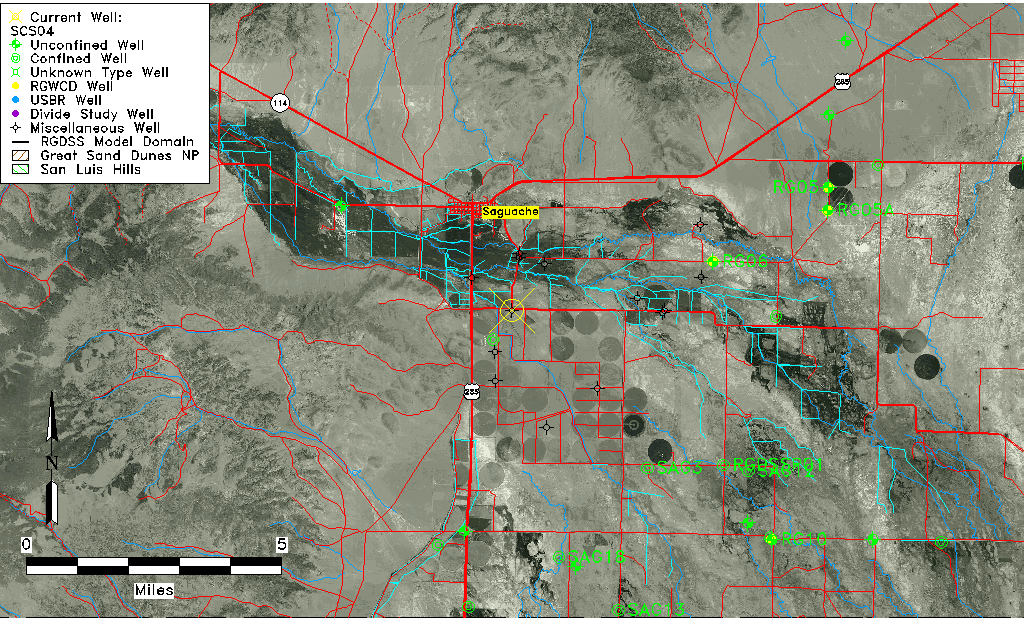
Common Well IDSCS04
USGS Site Use InformationUnknown
USGS Groundwater Use InformationUnknown
Data Source(s)Saguache Creek
Location Data
Longitude/Latitude (NAD83)-106.12721102 , 38.05832835
Longitude/Latitude Data SourceSaguach Ck Survey
Easting, Northing RGDSS-NAD83 (US ft)69587.80 , 387087.36
Elevation and Depth Data
Ground Elevation (ft NAVD88)7680.03000000000
Elevation Data SourceSaguache Creek survey
1/3-Arc Second NED Ground Elevation (ft NAVD88)7675.84
1-Arc Second NED Ground Elevation (ft NAVD88)7679.97
SRTM Ground Elevation (ft NAVD88)7696.79
Model Layer1
Model Layer SourceSaguache Layer
Depth of Bottom of Layer 194
Depth of Bottom of Layer 2178
Depth of Bottom of Layer 3278
Depth of Bottom of Layer 4348
Additional Well InformationNONE
Aquifer Information
Aquifer TypeUnconfined
Aquifer Type SourceTD Elevation/Model Layer
Water-level Database Information
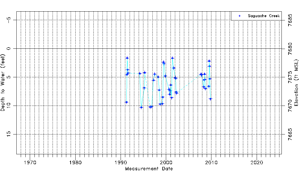
Water-level Count44
Water-level Date Range04/19/1991 thru 10/19/2009
Monitored within the last 18 monthsNo, most recently on 10/19/2009
Depth-to-Water Range (ft)1.68 to 10.30
Water Table Elevation Range (ft NAVD88)7669.73 to 7678.35
Water-Level-Source:Number-of-MeasurementsSaguache Creek:44

Top of Page


Water-level Data

1967 to Present

Top of Page


Measurement DateDepth to
Water (ft)
Elevation
(ft NAVD88)
Data
Source(s)
04/19/19919.387670.65Saguache Creek
05/11/19914.587675.45Saguache Creek
06/07/19911.687678.35Saguache Creek
07/15/19913.707676.33Saguache Creek
08/16/19914.297675.74Saguache Creek
03/15/19944.407675.63Saguache Creek
07/20/199410.307669.73Saguache Creek
03/17/19956.887673.15Saguache Creek
04/16/19954.247675.79Saguache Creek
07/01/199610.247669.79Saguache Creek
11/01/199610.167669.87Saguache Creek
04/01/19975.567674.47Saguache Creek
07/01/19974.487675.55Saguache Creek
04/04/19985.007675.03Saguache Creek
07/01/19987.287672.75Saguache Creek
09/14/19989.727670.31Saguache Creek
03/02/19999.657670.38Saguache Creek
04/12/19998.507671.53Saguache Creek
06/15/19992.407677.63Saguache Creek
07/19/19992.657677.38Saguache Creek
11/09/19994.807675.23Saguache Creek
08/31/20007.157672.88Saguache Creek
10/25/20008.007672.03Saguache Creek
12/12/20007.407672.63Saguache Creek
01/14/20016.407673.63Saguache Creek
03/26/20018.607671.43Saguache Creek
05/31/20011.707678.33Saguache Creek
09/10/20013.407676.63Saguache Creek
01/11/20025.107674.93Saguache Creek
02/18/20025.257674.78Saguache Creek
03/28/20027.607672.43Saguache Creek
05/02/20027.807672.23Saguache Creek
09/18/20074.507675.53Saguache Creek
11/01/20074.607675.43Saguache Creek
04/29/20086.707673.33Saguache Creek
06/01/20085.507674.53Saguache Creek
06/29/20084.507675.53Saguache Creek
07/28/20085.407674.63Saguache Creek
09/03/20087.007673.03Saguache Creek
06/06/20096.607673.43Saguache Creek
07/07/20092.207677.83Saguache Creek
08/01/20093.107676.93Saguache Creek
09/02/20095.307674.73Saguache Creek
10/19/20098.807671.23Saguache Creek

Top of Page