| Well Information Table |
|---|
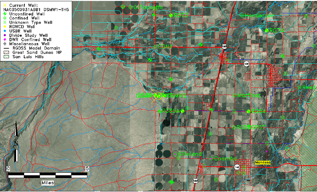
| Common Well ID | NA03500931ABB1 DSMW1-TH5 |
| RGWCD Well ID | DSMW1 |
| USGS Well ID | 371421106013801 |
| USGS Station Name | NA03500931ABB1 DSMW1-TH5 |
| USGS Construction Date | 02/06/2019 |
| USGS Site Type | Well |
| USGS Site Use Information | Unknown |
| USGS Groundwater Use Information | Unknown |
| Data Source(s) | USGS, RGWCD |
| Location Data |
|---|
| TRS | NA03500931ABB1 DSMW1-TH5 |
| RGWCD TRS | NA03500931ABB1 |
| USGS TRS 1 | NA03500931ABB1 DSMW1-TH5 |
| USGS TRS | NWNES31 T35N R09E N |
| Longitude/Latitude (NAD83) | -106.03364103 , 37.23867922 |
| Longitude/Latitude Data Source | RGWCD/Davis Engineering |
| RGWCD Longitude/Latitude (NAD83) | -106:02:01.1077 , 37:14:19.2452 |
| USGS Longitude/Latitude (NAD83) | -106.027125000 , 37.239094440 |
| Easting, Northing RGDSS-NAD83 (US ft) | 95358.80 , 88590.80 |
| USGS County | Conejos County |
| USGS Map Name | GOSHAWK DAM, CO |
| USGS Map Scale | 24000 |
| Elevation and Depth Data |
|---|
| Ground Elevation (ft NAVD88) | 7652.67 |
| Elevation Data Source | RGWCD well database |
| RGWCD Measuring Point Elevation (ft NAVD88) | 7654.690 |
| RGWCD Well Riser Height (ft) | 2.017 |
| RGWCD Ground Surface (ft NAVD88) | 7652.67 |
| USGS Ground Elevation (ft NAVD88) | 7651.00 |
| 1/3-Arc Second NED Ground Elevation (ft NAVD88) | 7652.71 |
| 1-Arc Second NED Ground Elevation (ft NAVD88) | 7652.64 |
| SRTM Ground Elevation (ft NAVD88) | 7657.75 |
| Total Depth (ft) | 24.00 |
| USGS Hole Depth (ft) | 31.00 |
| USGS Well Depth (ft) | 31.00 |
| Model Layer | 1 |
| Model Layer Source | RGWCD |
| Depth of Bottom of Layer 1 | 38 |
| Depth of Bottom of Layer 2 | 76 |
| Depth of Bottom of Layer 3 | 129 |
| Depth of Bottom of Layer 4 | 1155 |
| Additional Well Information | NONE |
| Aquifer Information |
|---|
| Aquifer Type | Unconfined |
| Aquifer Type Source | RGWCD_AQ |
| USGS Primary Aquifer | Holocene Alluvium |
| USGS Aquifer Type | Unconfined Single Aquifer |
| USGS Hydrologic Unit | Alamosa-Trinchera |
| USGS Data Available | Miscellaneous (GW.MISC) |
| Water-level Database Information |
|---|
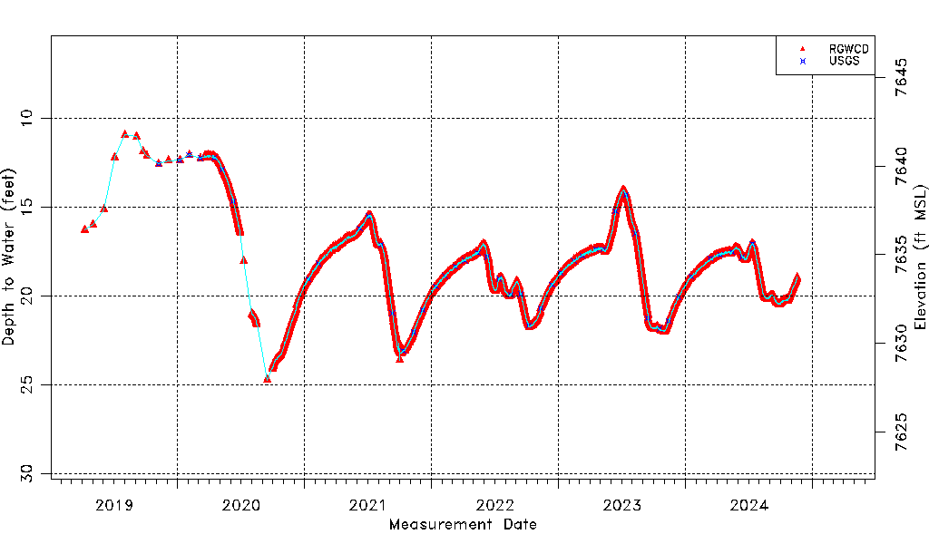
| Water-level Count | 8912 |
| Water-level Date Range | 04/08/2019 thru 06/05/2026 |
| Monitored within the last 18 months | Yes, most recently on 06/05/2026 |
| Depth-to-Water Range (ft) | 10.90 to 24.72 |
| Water Table Elevation Range (ft NAVD88) | 7627.95 to 7641.77 |
| Water-Level-Source:Number-of-Measurements | RGWCD:8906 USGS:48 |