| Well Information Table |
|---|
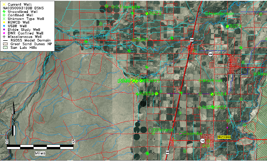
| Common Well ID | NA03500931BBB DSNS |
| RGWCD Well ID | DSNS |
| USGS Well ID | 371422106021501 |
| USGS Station Name | NA03500931BBB DSNS |
| USGS Construction Date | 01/30/2019 |
| USGS Site Type | Well |
| USGS Site Use Information | Unknown |
| USGS Groundwater Use Information | Unknown |
| Data Source(s) | USGS, RGWCD |
| Location Data |
|---|
| TRS | NA03500931BBB DSNS |
| RGWCD TRS | NA03500931BBB |
| USGS TRS 1 | NA03500931BBB DSNS |
| USGS TRS | S31 T35N R09E N |
| Longitude/Latitude (NAD83) | -106.03754069 , 37.23942394 |
| Longitude/Latitude Data Source | RGWCD/Davis Engineering |
| RGWCD Longitude/Latitude (NAD83) | -106:02:15.1465 , 37:14:21.9262 |
| USGS Longitude/Latitude (NAD83) | -106.037466700 , 37.239447200 |
| Easting, Northing RGDSS-NAD83 (US ft) | 94224.93 , 88866.21 |
| USGS County | Conejos County |
| USGS Map Name | GOSHAWK DAM, CO |
| USGS Map Scale | 24000 |
| Elevation and Depth Data |
|---|
| Ground Elevation (ft NAVD88) | 7649.94 |
| Elevation Data Source | RGWCD well database |
| RGWCD Measuring Point Elevation (ft NAVD88) | 7652.038 |
| RGWCD Well Riser Height (ft) | 2.097 |
| RGWCD Ground Surface (ft NAVD88) | 7649.94 |
| USGS Ground Elevation (ft NAVD88) | 7657.00 |
| 1/3-Arc Second NED Ground Elevation (ft NAVD88) | 7651.14 |
| 1-Arc Second NED Ground Elevation (ft NAVD88) | 7653.03 |
| SRTM Ground Elevation (ft NAVD88) | 7654.44 |
| Total Depth (ft) | 22.00 |
| USGS Hole Depth (ft) | 22.00 |
| USGS Well Depth (ft) | 22.00 |
| Model Layer | 1 |
| Model Layer Source | RGWCD |
| Depth of Bottom of Layer 1 | 31 |
| Depth of Bottom of Layer 2 | 68 |
| Depth of Bottom of Layer 3 | 117 |
| Depth of Bottom of Layer 4 | 1027 |
| Additional Well Information | NONE |
| Aquifer Information |
|---|
| Aquifer Type | Unconfined |
| Aquifer Type Source | RGWCD_AQ |
| USGS Primary Aquifer | Holocene Alluvium |
| USGS Aquifer Type | Unconfined Single Aquifer |
| USGS Hydrologic Unit | Alamosa-Trinchera |
| USGS Data Available | Miscellaneous (GW.MISC) |
| Water-level Database Information |
|---|
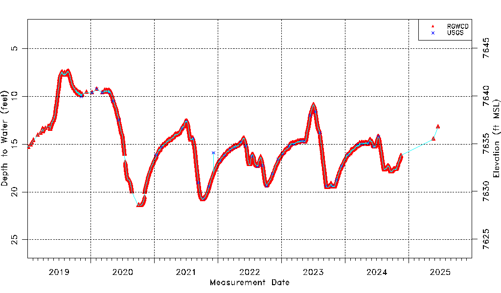
| Water-level Count | 9756 |
| Water-level Date Range | 12/18/2018 thru 06/05/2026 |
| Monitored within the last 18 months | Yes, most recently on 06/05/2026 |
| Depth-to-Water Range (ft) | 7.39 to 21.44 |
| Water Table Elevation Range (ft NAVD88) | 7628.50 to 7642.55 |
| Water-Level-Source:Number-of-Measurements | RGWCD:9748 USGS:48 |