| Well Information Table |
|---|
| Common Well ID | NA04101015CCC3 EW-39C-2 |
| USBR Well ID | EW39C2 |
| USGS Well ID | 374736105522103 |
| GSDNP Well Name | 374736105522103 |
| USGS Station Name | NA04101015CCC3 EW-39C-2 |
| USGS Construction Date | 05/11/1994 |
| USGS Site Type | Well |
| USGS Site Use Information | Observation |
| USGS Groundwater Use Information | Unknown |
| Data Source(s) | USGS, USBR |
| Location Data |
|---|
| TRS | NA04101015CCC3 EW-39C-2 |
| USBR TRS | NA04101015CCC3 |
| USGS TRS 1 | NA04101015CCC3 EW-39C-2 |
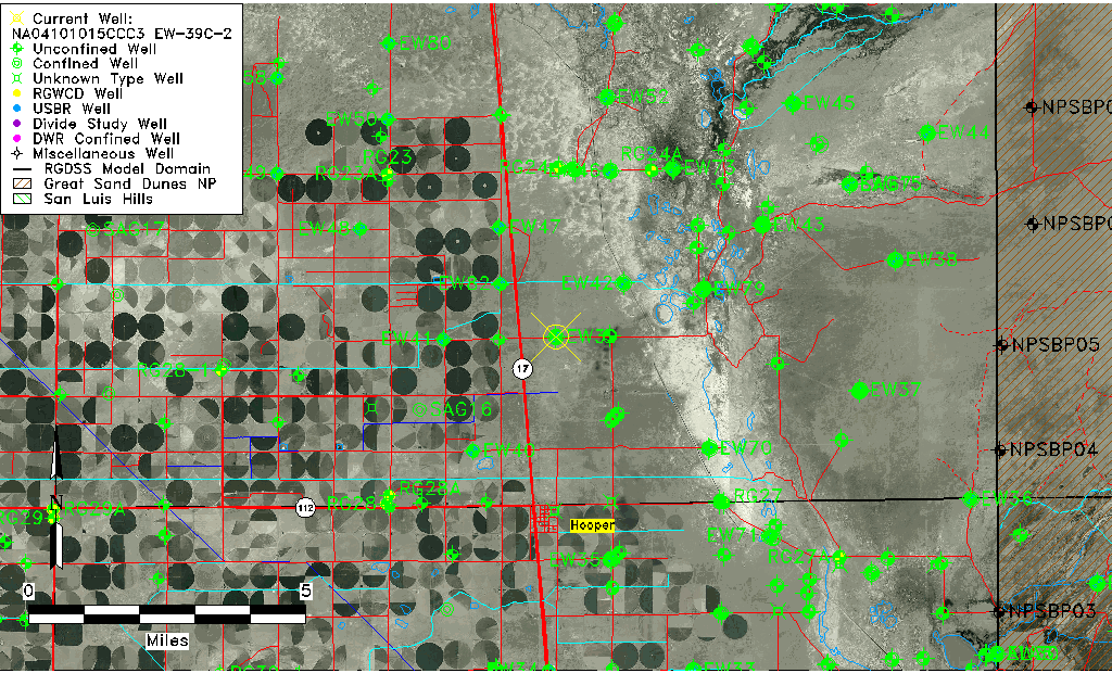
| Longitude/Latitude (NAD83) | -105.87325971 , 37.79353743 |
| Longitude/Latitude Data Source | USBOR EW well locations |
| USGS Longitude/Latitude (NAD83) | -105.873075400 , 37.793332900 |
| USBR Longitude/Latitude (NAD27) | -105.872684295898 , 37.7935378554686 |
| Easting, Northing RGDSS-NAD83 (US ft) | 142470.04 , 290427.77 |
| USGS County | Saguache County |
| Elevation and Depth Data |
|---|
| Ground Elevation (ft NAVD88) | 7544.55 |
| Elevation Data Source | USBOR EW well database |
| USBR Ground Elevation (ft NGVD29) | 7540.7 |
| USGS Ground Elevation (ft NGVD29) | 7540.70 |
| 1/3-Arc Second NED Ground Elevation (ft NAVD88) | 7543.98 |
| 1-Arc Second NED Ground Elevation (ft NAVD88) | 7544.84 |
| SRTM Ground Elevation (ft NAVD88) | 7554.90 |
| Total Depth (ft) | 260.00 |
| USBR Total Depth (ft) | 260 |
| USGS Well Depth (ft) | 149.00 |
| Model Layer | 3 |
| Model Layer Source | Well Depth |
| Depth of Bottom of Layer 1 | 106 |
| Depth of Bottom of Layer 2 | 246 |
| Depth of Bottom of Layer 3 | 1386 |
| Depth of Bottom of Layer 4 | 3283 |
| Additional Well Information | Construction |
| Aquifer Information |
|---|
| Aquifer Type | Confined |
| Aquifer Type Source | EW_AQFR |
| USGS Aquifer Type | Confined Single Aquifer |
| USGS Hydrologic Unit | San Luis |
| USGS Data Available | Water-level (GW.LEV) |
| Water-level Database Information |
|---|
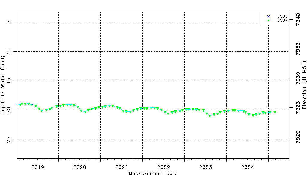
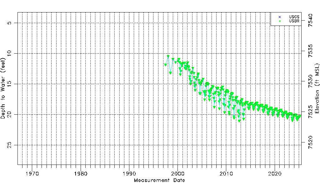
| Water-level Count | 313 |
| Water-level Date Range | 06/25/1997 thru 09/15/2025 |
| Monitored within the last 18 months | Yes, most recently on 09/15/2025 |
| Depth-to-Water Range (ft) | 10.42 to 21.04 |
| Water Table Elevation Range (ft NAVD88) | 7523.51 to 7534.13 |
| Water-Level-Source:Number-of-Measurements | USGS:45 USBR:306 |