| Well Information Table |
|---|
| Common Well ID | DIV12464 |
| USGS Site Use Information | Unknown |
| USGS Groundwater Use Information | Unknown |
| Data Source(s) | Divide Study |
| Location Data |
|---|
| Longitude/Latitude (NAD83) | -106.26430745 , 37.66465194 |
| Longitude/Latitude Data Source | Divide Study |
| Easting, Northing RGDSS-NAD83 (US ft) | 29203.51 , 243994.33 |
| Elevation and Depth Data |
|---|
| Ground Elevation (ft NAVD88) | 7793.28 |
| Elevation Data Source | Divide study surveying by Davis Engineering |
| 1/3-Arc Second NED Ground Elevation (ft NAVD88) | 7793.66 |
| 1-Arc Second NED Ground Elevation (ft NAVD88) | 7792.81 |
| SRTM Ground Elevation (ft NAVD88) | 7801.43 |
| Model Layer | 1 |
| Model Layer Source | Aquifer Type |
| Depth of Bottom of Layer 1 | 49 |
| Depth of Bottom of Layer 2 | 175 |
| Depth of Bottom of Layer 3 | 219 |
| Depth of Bottom of Layer 4 | 346 |
| Additional Well Information | NONE |
| Aquifer Information |
|---|
| Aquifer Type | Unconfined |
| Aquifer Type Source | DIV_AQ |
| Water-level Database Information |
|---|
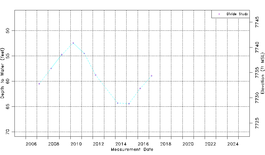
| Water-level Count | 10 |
| Water-level Date Range | 03/20/2007 thru 03/28/2017 |
| Monitored within the last 18 months | No, most recently on 03/28/2017 |
| Depth-to-Water Range (ft) | 52.42 to 64.42 |
| Water Table Elevation Range (ft NAVD88) | 7728.86 to 7740.86 |
| Water-Level-Source:Number-of-Measurements | Divide Study:10 |