| Well Information Table |
|---|
| Common Well ID | DUN15 |
| GSDNP Well Name | 15 |
| USGS Site Use Information | Unknown |
| USGS Groundwater Use Information | Unknown |
| Data Source(s) | HRS |
| Location Data |
|---|
| Longitude/Latitude (NAD83) | -105.73254935 , 37.70171902 |
| Longitude/Latitude Data Source | HRS Dunes database |
| Easting, Northing RGDSS-NAD83 (US ft) | 183093.70 , 256944.62 |
| Elevation and Depth Data |
|---|
| Ground Elevation (ft NAVD88) | 7529.95 |
| Elevation Data Source | CSU well databse |
| CSU Dunes Well database (ft NGVD29) | 7525.89 |
| HRS Dunes Well database (ft NGVD29) | 7525.89014 |
| 1/3-Arc Second NED Ground Elevation (ft NAVD88) | 7529.14 |
| 1-Arc Second NED Ground Elevation (ft NAVD88) | 7528.17 |
| SRTM Ground Elevation (ft NAVD88) | 7536.60 |
| Model Layer | 1 |
| Model Layer Source | Aquifer Type |
| Depth of Bottom of Layer 1 | 137 |
| Depth of Bottom of Layer 2 | 436 |
| Depth of Bottom of Layer 3 | 1633 |
| Depth of Bottom of Layer 4 | 3290 |
| Additional Well Information | NONE |
| Aquifer Information |
|---|
| Aquifer Type | Unconfined |
| Aquifer Type Source | HRS_AQUIFER |
| Water-level Database Information |
|---|
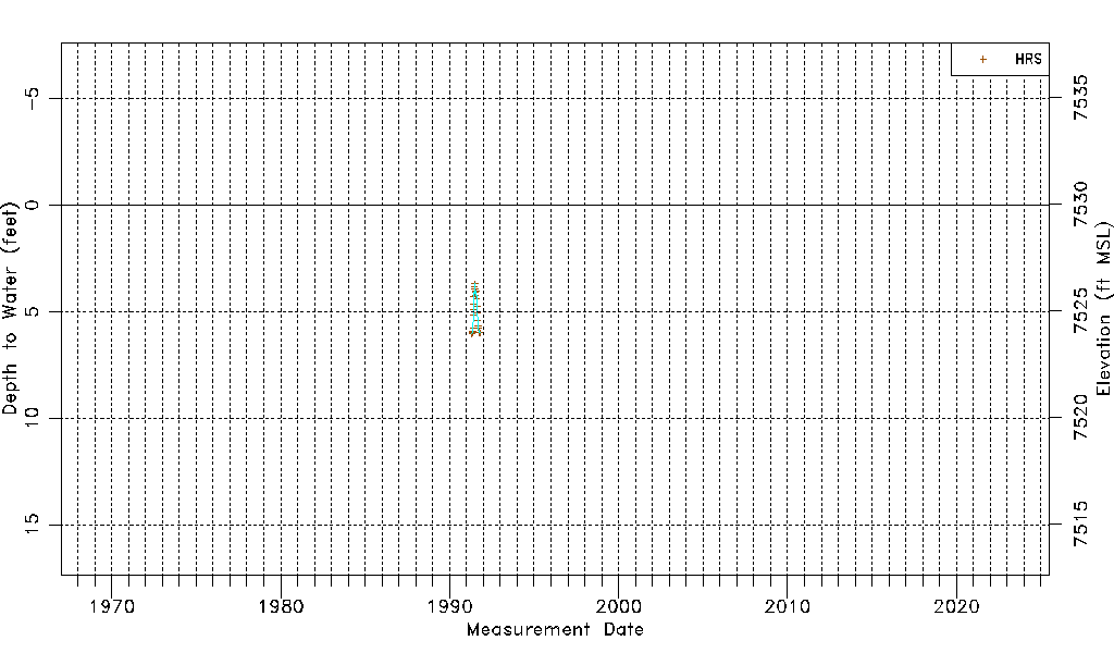
| Water-level Count | 22 |
| Water-level Date Range | 04/30/1991 thru 10/14/1991 |
| Monitored within the last 18 months | No, most recently on 10/14/1991 |
| Depth-to-Water Range (ft) | 3.69 to 6.04 |
| Water Table Elevation Range (ft NAVD88) | 7523.91 to 7526.26 |
| Water-Level-Source:Number-of-Measurements | HRS:22 |