| Well Information Table |
|---|
| Common Well ID | DUN17 |
| GSDNP Well Name | 17 |
| USGS Site Use Information | Unknown |
| USGS Groundwater Use Information | Unknown |
| Data Source(s) | HRS |
| Location Data |
|---|
| Longitude/Latitude (NAD83) | -105.73209013 , 37.70116305 |
| Longitude/Latitude Data Source | HRS Dunes database |
| Easting, Northing RGDSS-NAD83 (US ft) | 183226.38 , 256742.14 |
| Elevation and Depth Data |
|---|
| Ground Elevation (ft NAVD88) | 7527.27 |
| Elevation Data Source | CSU well databse |
| CSU Dunes Well database (ft NGVD29) | 7523.21 |
| HRS Dunes Well database (ft NGVD29) | 7523.20996 |
| 1/3-Arc Second NED Ground Elevation (ft NAVD88) | 7529.14 |
| 1-Arc Second NED Ground Elevation (ft NAVD88) | 7528.03 |
| SRTM Ground Elevation (ft NAVD88) | 7529.82 |
| Model Layer | 1 |
| Model Layer Source | Aquifer Type |
| Depth of Bottom of Layer 1 | 134 |
| Depth of Bottom of Layer 2 | 435 |
| Depth of Bottom of Layer 3 | 1632 |
| Depth of Bottom of Layer 4 | 3297 |
| Additional Well Information | NONE |
| Aquifer Information |
|---|
| Aquifer Type | Unconfined |
| Aquifer Type Source | HRS_AQUIFER |
| Water-level Database Information |
|---|
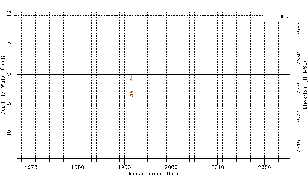
| Water-level Count | 22 |
| Water-level Date Range | 04/30/1991 thru 10/14/1991 |
| Monitored within the last 18 months | No, most recently on 10/14/1991 |
| Depth-to-Water Range (ft) | 0.04 to 3.65 |
| Water Table Elevation Range (ft NAVD88) | 7523.62 to 7527.23 |
| Water-Level-Source:Number-of-Measurements | HRS:22 |