| Well Information Table |
|---|
| Common Well ID | DUN28 |
| GSDNP Well Name | 28 |
| USGS Site Use Information | Unknown |
| USGS Groundwater Use Information | Unknown |
| Data Source(s) | HRS |
| Location Data |
|---|
| Longitude/Latitude (NAD83) | -105.72928385 , 37.69955807 |
| Longitude/Latitude Data Source | HRS Dunes database |
| Easting, Northing RGDSS-NAD83 (US ft) | 184037.64 , 256157.36 |
| Elevation and Depth Data |
|---|
| Ground Elevation (ft NAVD88) | 7527.05 |
| Elevation Data Source | CSU well databse |
| CSU Dunes Well database (ft NGVD29) | 7522.99 |
| HRS Dunes Well database (ft NGVD29) | 7522.99023 |
| 1/3-Arc Second NED Ground Elevation (ft NAVD88) | 7533.79 |
| 1-Arc Second NED Ground Elevation (ft NAVD88) | 7532.50 |
| SRTM Ground Elevation (ft NAVD88) | 7536.09 |
| Model Layer | 1 |
| Model Layer Source | Aquifer Type |
| Depth of Bottom of Layer 1 | 138 |
| Depth of Bottom of Layer 2 | 440 |
| Depth of Bottom of Layer 3 | 1632 |
| Depth of Bottom of Layer 4 | 3352 |
| Additional Well Information | NONE |
| Aquifer Information |
|---|
| Aquifer Type | Unconfined |
| Aquifer Type Source | HRS_AQUIFER |
| Water-level Database Information |
|---|
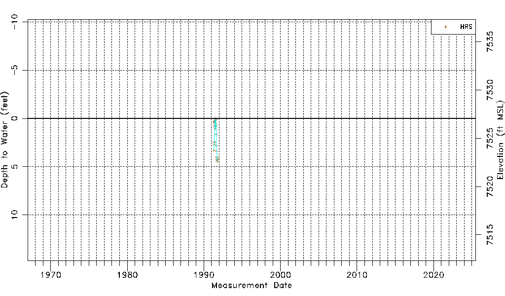
| Water-level Count | 22 |
| Water-level Date Range | 04/30/1991 thru 10/14/1991 |
| Monitored within the last 18 months | No, most recently on 10/14/1991 |
| Depth-to-Water Range (ft) | 0.03 to 4.42 |
| Water Table Elevation Range (ft NAVD88) | 7522.63 to 7527.02 |
| Water-Level-Source:Number-of-Measurements | HRS:22 |