| Well Information Table |
|---|
| Common Well ID | DUN34 |
| GSDNP Well Name | 34 |
| USGS Site Use Information | Unknown |
| USGS Groundwater Use Information | Unknown |
| Data Source(s) | HRS |
| Location Data |
|---|
| Longitude/Latitude (NAD83) | -105.73179662 , 37.71054760 |
| Longitude/Latitude Data Source | HRS Dunes database |
| Easting, Northing RGDSS-NAD83 (US ft) | 183313.62 , 260158.21 |
| Elevation and Depth Data |
|---|
| Ground Elevation (ft NAVD88) | 7526.31 |
| Elevation Data Source | CSU well databse |
| CSU Dunes Well database (ft NGVD29) | 7522.24 |
| HRS Dunes Well database (ft NGVD29) | 7522.24023 |
| 1/3-Arc Second NED Ground Elevation (ft NAVD88) | 7529.53 |
| 1-Arc Second NED Ground Elevation (ft NAVD88) | 7530.83 |
| SRTM Ground Elevation (ft NAVD88) | 7534.39 |
| Model Layer | 1 |
| Model Layer Source | Aquifer Type |
| Depth of Bottom of Layer 1 | 130 |
| Depth of Bottom of Layer 2 | 423 |
| Depth of Bottom of Layer 3 | 1615 |
| Depth of Bottom of Layer 4 | 3276 |
| Additional Well Information | NONE |
| Aquifer Information |
|---|
| Aquifer Type | Unconfined |
| Aquifer Type Source | HRS_AQUIFER |
| Water-level Database Information |
|---|
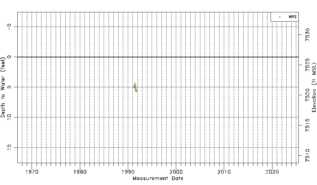
| Water-level Count | 22 |
| Water-level Date Range | 04/30/1991 thru 10/14/1991 |
| Monitored within the last 18 months | No, most recently on 10/14/1991 |
| Depth-to-Water Range (ft) | 4.38 to 5.73 |
| Water Table Elevation Range (ft NAVD88) | 7520.58 to 7521.93 |
| Water-Level-Source:Number-of-Measurements | HRS:22 |