| Well Information Table |
|---|
| Common Well ID | DUNDHPW1 |
| GSDNP Well Name | DHPW-1 |
| USGS Site Use Information | Unknown |
| USGS Groundwater Use Information | Unknown |
| Data Source(s) | HRS |
| Location Data |
|---|
| Longitude/Latitude (NAD83) | -105.79558971 , 37.85478958 |
| Longitude/Latitude Data Source | BACA wells reported by Halepaska |
| Halapaska & Assoc. Easting/Northing (CO-S) | 1914822.00000000 , 432744.000000000 |
| Easting, Northing RGDSS-NAD83 (US ft) | 164937.86 , 312684.70 |
| Elevation and Depth Data |
|---|
| Ground Elevation (ft NAVD88) | 7544.02 |
| Elevation Data Source | BACA well (HRS from topo) |
| BACA Well database (HRS, ft NGVD29) | 7540 |
| HRS Dunes Well database (ft NGVD29) | 7540.00000 |
| 1/3-Arc Second NED Ground Elevation (ft NAVD88) | 7543.98 |
| 1-Arc Second NED Ground Elevation (ft NAVD88) | 7543.81 |
| SRTM Ground Elevation (ft NAVD88) | 7543.75 |
| Total Depth (ft) | 6.20 |
| Model Layer | 1 |
| Model Layer Source | Dunes Layer |
| Depth of Bottom of Layer 1 | 112 |
| Depth of Bottom of Layer 2 | 346 |
| Depth of Bottom of Layer 3 | 1683 |
| Depth of Bottom of Layer 4 | 4438 |
| Additional Well Information | NONE |
| Aquifer Information |
|---|
| Aquifer Type | Unconfined |
| Aquifer Type Source | HRS_AQUIFER |
| Water-level Database Information |
|---|
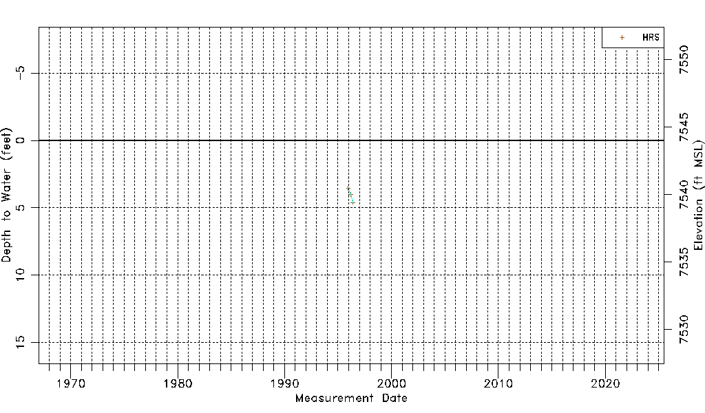
| Water-level Count | 3 |
| Water-level Date Range | 12/13/1995 thru 05/22/1996 |
| Monitored within the last 18 months | No, most recently on 05/22/1996 |
| Depth-to-Water Range (ft) | 3.54 to 4.60 |
| Water Table Elevation Range (ft NAVD88) | 7539.42 to 7540.48 |
| Water-Level-Source:Number-of-Measurements | HRS:3 |