| Well Information Table |
|---|
| Common Well ID | DUNDW10 |
| GSDNP Well Name | DUNDW10 |
| USGS Site Use Information | Unknown |
| USGS Groundwater Use Information | Unknown |
| Data Source(s) | HRS, HRS |
| Location Data |
|---|
| Longitude/Latitude (NAD83) | -105.64656715 , 37.90116284 |
| Longitude/Latitude Data Source | HRS Dunes database |
| Easting, Northing RGDSS-NAD83 (US ft) | 207946.94 , 329539.74 |
| Elevation and Depth Data |
|---|
| Ground Elevation (ft NAVD88) | 7854.27 |
| Elevation Data Source | BACA well (Halepaska) |
| BACA Well database (Halapaska & Assoc, ft NGVD29) | 7850 |
| HRS Dunes Well database (ft NGVD29) | 7850.00000 |
| 1/3-Arc Second NED Ground Elevation (ft NAVD88) | 7881.37 |
| 1-Arc Second NED Ground Elevation (ft NAVD88) | 7885.14 |
| SRTM Ground Elevation (ft NAVD88) | 7897.01 |
| Total Depth (ft) | 248.00 |
| Model Layer | 2 |
| Model Layer Source | Aquifer Type |
| Depth of Bottom of Layer 1 | 365 |
| Depth of Bottom of Layer 2 | 754 |
| Depth of Bottom of Layer 3 | 1081 |
| Depth of Bottom of Layer 4 | 1495 |
| Additional Well Information | NONE |
| Aquifer Information |
|---|
| Aquifer Type | Confined |
| Aquifer Type Source | HRS_AQUIFER |
| Water-level Database Information |
|---|
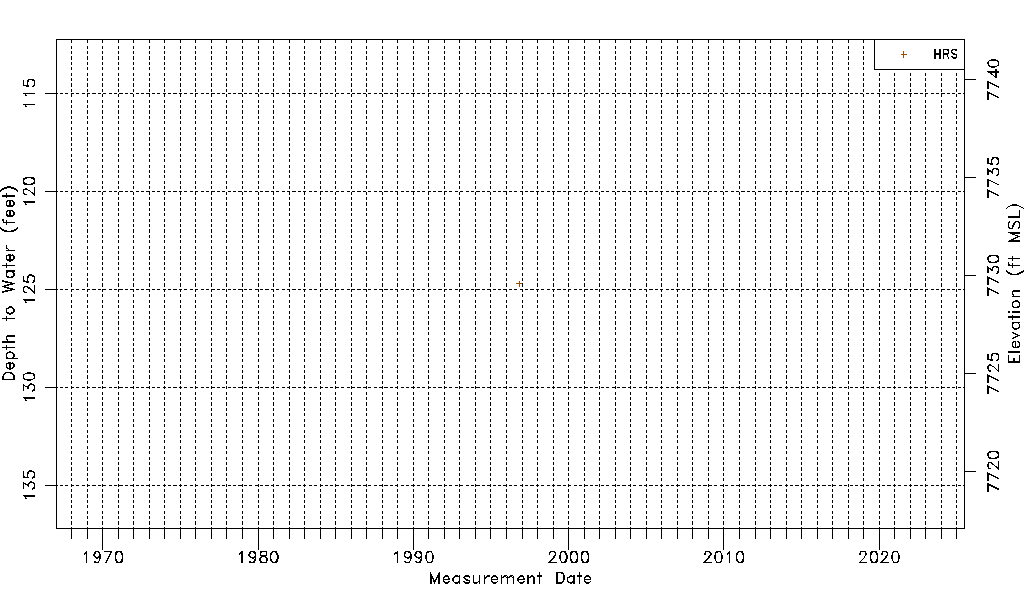
| Water-level Count | 1 |
| Water-level Date Range | 10/30/1996 thru 10/30/1996 |
| Monitored within the last 18 months | No, most recently on 10/30/1996 |
| Depth-to-Water Range (ft) | 124.70 to 124.70 |
| Water Table Elevation Range (ft NAVD88) | 7729.57 to 7729.57 |
| Water-Level-Source:Number-of-Measurements | HRS:1 |