| Well Information Table |
|---|
| Common Well ID | DUNDW7 |
| GSDNP Well Name | DW-7 |
| USGS Site Use Information | Unknown |
| USGS Groundwater Use Information | Unknown |
| Data Source(s) | HRS |
| Location Data |
|---|
| Longitude/Latitude (NAD83) | -105.78622760 , 37.84396192 |
| Longitude/Latitude Data Source | BACA wells reported by Halepaska |
| Halapaska & Assoc. Easting/Northing (CO-S) | 1917513.00000000 , 428793.000000000 |
| Easting, Northing RGDSS-NAD83 (US ft) | 167634.96 , 308739.49 |
| Elevation and Depth Data |
|---|
| Ground Elevation (ft NAVD88) | 7544.04 |
| Elevation Data Source | BACA well (Halepaska) |
| BACA Well database (Halapaska & Assoc, ft NGVD29) | 7540 |
| HRS Dunes Well database (ft NGVD29) | 7540.00000 |
| 1/3-Arc Second NED Ground Elevation (ft NAVD88) | 7543.99 |
| 1-Arc Second NED Ground Elevation (ft NAVD88) | 7544.77 |
| SRTM Ground Elevation (ft NAVD88) | 7555.77 |
| Total Depth (ft) | 957.00 |
| Model Layer | 3 |
| Model Layer Source | Well Depth |
| Depth of Bottom of Layer 1 | 111 |
| Depth of Bottom of Layer 2 | 350 |
| Depth of Bottom of Layer 3 | 1709 |
| Depth of Bottom of Layer 4 | 4282 |
| Additional Well Information | NONE |
| Aquifer Information |
|---|
| Aquifer Type | Confined |
| Aquifer Type Source | HRS_AQUIFER |
| Water-level Database Information |
|---|
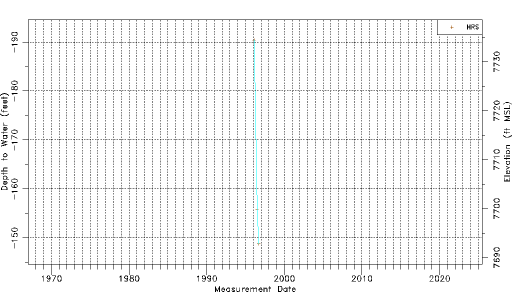
| Water-level Count | 3 |
| Water-level Date Range | 02/09/1996 thru 09/18/1996 |
| Monitored within the last 18 months | No, most recently on 09/18/1996 |
| Depth-to-Water Range (ft) | -190.40 to -148.80 |
| Water Table Elevation Range (ft NAVD88) | 7692.84 to 7734.44 |
| Water-Level-Source:Number-of-Measurements | HRS:3 |