| Well Information Table |
|---|
| Common Well ID | DUNNLPW2 |
| GSDNP Well Name | NLPW-2 |
| USGS Site Use Information | Unknown |
| USGS Groundwater Use Information | Unknown |
| Data Source(s) | HRS |
| Location Data |
|---|
| Longitude/Latitude (NAD83) | -105.76260513 , 37.94633839 |
| Longitude/Latitude Data Source | BACA wells reported by Halepaska |
| Halapaska & Assoc. Easting/Northing (CO-S) | 1924438.00000000 , 466051.000000000 |
| Easting, Northing RGDSS-NAD83 (US ft) | 174493.41 , 345999.48 |
| Elevation and Depth Data |
|---|
| Ground Elevation (ft NAVD88) | 7610.19 |
| Elevation Data Source | BACA well (HRS from topo) |
| BACA Well database (HRS, ft NGVD29) | 7606 |
| HRS Dunes Well database (ft NGVD29) | 7606.00000 |
| 1/3-Arc Second NED Ground Elevation (ft NAVD88) | 7609.83 |
| 1-Arc Second NED Ground Elevation (ft NAVD88) | 7608.05 |
| SRTM Ground Elevation (ft NAVD88) | 7613.81 |
| Total Depth (ft) | 7.25 |
| Model Layer | 1 |
| Model Layer Source | Dunes Layer |
| Depth of Bottom of Layer 1 | 225 |
| Depth of Bottom of Layer 2 | 477 |
| Depth of Bottom of Layer 3 | 1545 |
| Depth of Bottom of Layer 4 | 3737 |
| Additional Well Information | NONE |
| Aquifer Information |
|---|
| Aquifer Type | Unconfined |
| Aquifer Type Source | HRS_AQUIFER |
| Water-level Database Information |
|---|
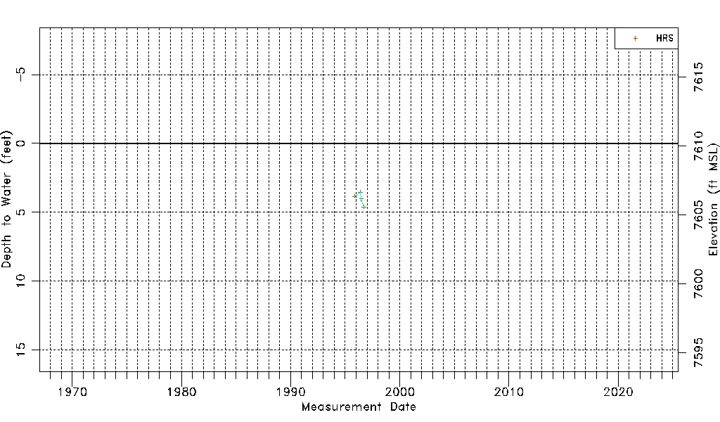
| Water-level Count | 4 |
| Water-level Date Range | 11/08/1995 thru 09/19/1996 |
| Monitored within the last 18 months | No, most recently on 09/19/1996 |
| Depth-to-Water Range (ft) | 3.55 to 4.60 |
| Water Table Elevation Range (ft NAVD88) | 7605.59 to 7606.64 |
| Water-Level-Source:Number-of-Measurements | HRS:4 |