| Well Information Table |
|---|
| Common Well ID | DUNNSMW3 |
| GSDNP Well Name | NSMW-3 |
| USGS Site Use Information | Unknown |
| USGS Groundwater Use Information | Unknown |
| Data Source(s) | HRS |
| Location Data |
|---|
| Longitude/Latitude (NAD83) | -105.82290584 , 37.95448836 |
| Longitude/Latitude Data Source | BACA wells reported by Halepaska |
| Halapaska & Assoc. Easting/Northing (CO-S) | 1907060.00000000 , 469073.000000000 |
| Easting, Northing RGDSS-NAD83 (US ft) | 157115.29 , 348990.46 |
| Elevation and Depth Data |
|---|
| Ground Elevation (ft NAVD88) | 7570.12 |
| Elevation Data Source | BACA well (HRS from topo) |
| BACA Well database (HRS, ft NGVD29) | 7566 |
| HRS Dunes Well database (ft NGVD29) | 7566.00000 |
| 1/3-Arc Second NED Ground Elevation (ft NAVD88) | 7569.71 |
| 1-Arc Second NED Ground Elevation (ft NAVD88) | 7571.47 |
| SRTM Ground Elevation (ft NAVD88) | 7573.43 |
| Total Depth (ft) | 5.40 |
| Model Layer | 1 |
| Model Layer Source | Dunes Layer |
| Depth of Bottom of Layer 1 | 128 |
| Depth of Bottom of Layer 2 | 310 |
| Depth of Bottom of Layer 3 | 1453 |
| Depth of Bottom of Layer 4 | 4502 |
| Additional Well Information | NONE |
| Aquifer Information |
|---|
| Aquifer Type | Unconfined |
| Aquifer Type Source | HRS_AQUIFER |
| Water-level Database Information |
|---|
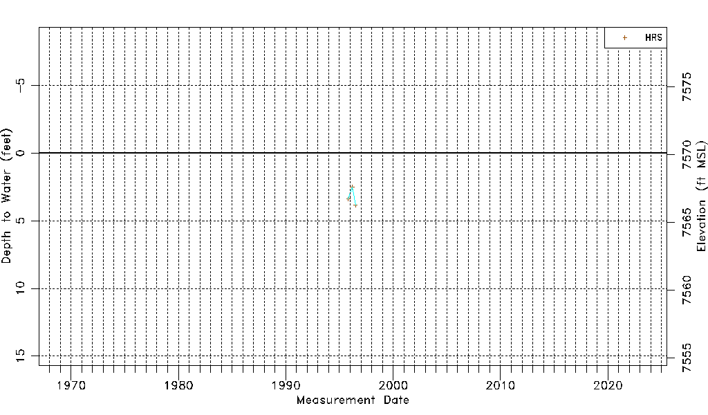
| Water-level Count | 3 |
| Water-level Date Range | 11/01/1995 thru 06/28/1996 |
| Monitored within the last 18 months | No, most recently on 06/28/1996 |
| Depth-to-Water Range (ft) | 2.52 to 3.86 |
| Water Table Elevation Range (ft NAVD88) | 7566.26 to 7567.60 |
| Water-Level-Source:Number-of-Measurements | HRS:3 |