| Well Information Table |
|---|
| Common Well ID | DUNR |
| GSDNP Well Name | R |
| USGS Site Use Information | Unknown |
| USGS Groundwater Use Information | Unknown |
| Data Source(s) | HRS |
| Location Data |
|---|
| Longitude/Latitude (NAD83) | -105.64826892 , 37.79616646 |
| Longitude/Latitude Data Source | HRS Dunes database |
| Easting, Northing RGDSS-NAD83 (US ft) | 207462.94 , 291318.81 |
| Elevation and Depth Data |
|---|
| Ground Elevation (ft NAVD88) | 7704.23 |
| Elevation Data Source | HRS Dunes database |
| HRS Dunes Well database (ft NGVD29) | 7700.00000 |
| 1/3-Arc Second NED Ground Elevation (ft NAVD88) | 7708.50 |
| 1-Arc Second NED Ground Elevation (ft NAVD88) | 7694.37 |
| SRTM Ground Elevation (ft NAVD88) | 7709.47 |
| Model Layer | 1 |
| Model Layer Source | Aquifer Type |
| Depth of Bottom of Layer 1 | 258 |
| Depth of Bottom of Layer 2 | 637 |
| Depth of Bottom of Layer 3 | 1309 |
| Depth of Bottom of Layer 4 | 2596 |
| Additional Well Information | NONE |
| Aquifer Information |
|---|
| Aquifer Type | Unconfined |
| Aquifer Type Source | HRS_AQUIFER |
| Water-level Database Information |
|---|
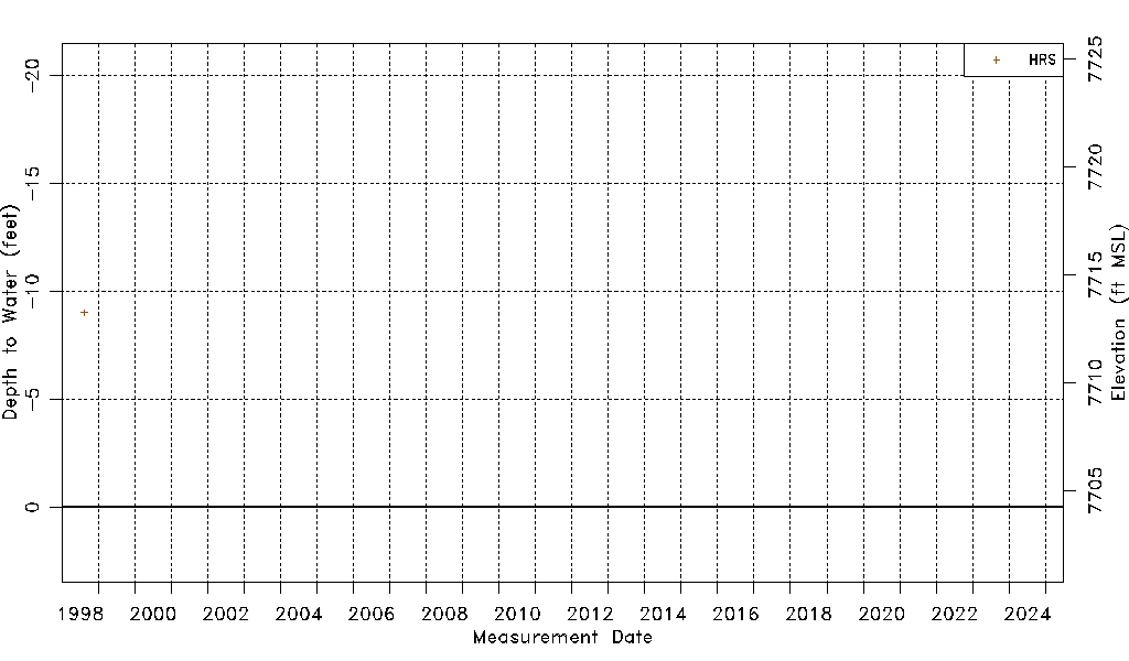
| Water-level Count | 1 |
| Water-level Date Range | 08/14/1998 thru 08/14/1998 |
| Monitored within the last 18 months | No, most recently on 08/14/1998 |
| Depth-to-Water Range (ft) | -9.02 to -9.02 |
| Water Table Elevation Range (ft NAVD88) | 7713.25 to 7713.25 |
| Water-Level-Source:Number-of-Measurements | HRS:1 |