| Well Information Table |
|---|
| Common Well ID | DUNT |
| GSDNP Well Name | T |
| USGS Site Use Information | Unknown |
| USGS Groundwater Use Information | Unknown |
| Data Source(s) | HRS |
| Location Data |
|---|
| Longitude/Latitude (NAD83) | -105.64580551 , 37.79239443 |
| Longitude/Latitude Data Source | HRS Dunes database |
| Easting, Northing RGDSS-NAD83 (US ft) | 208174.80 , 289945.87 |
| Elevation and Depth Data |
|---|
| Ground Elevation (ft NAVD88) | 7704.24 |
| Elevation Data Source | HRS Dunes database |
| HRS Dunes Well database (ft NGVD29) | 7700.00000 |
| 1/3-Arc Second NED Ground Elevation (ft NAVD88) | 7704.39 |
| 1-Arc Second NED Ground Elevation (ft NAVD88) | 7699.79 |
| SRTM Ground Elevation (ft NAVD88) | 7694.23 |
| Model Layer | 1 |
| Model Layer Source | Aquifer Type |
| Depth of Bottom of Layer 1 | 259 |
| Depth of Bottom of Layer 2 | 639 |
| Depth of Bottom of Layer 3 | 1310 |
| Depth of Bottom of Layer 4 | 2595 |
| Additional Well Information | NONE |
| Aquifer Information |
|---|
| Aquifer Type | Unconfined |
| Aquifer Type Source | HRS_AQUIFER |
| Water-level Database Information |
|---|
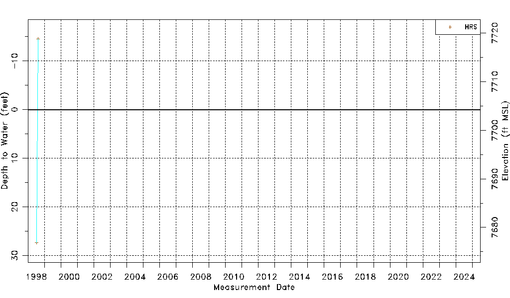
| Water-level Count | 2 |
| Water-level Date Range | 07/12/1998 thru 08/14/1998 |
| Monitored within the last 18 months | No, most recently on 08/14/1998 |
| Depth-to-Water Range (ft) | -14.52 to 27.40 |
| Water Table Elevation Range (ft NAVD88) | 7676.84 to 7718.76 |
| Water-Level-Source:Number-of-Measurements | HRS:2 |