| Well Information Table |
|---|
| Common Well ID | DUNWELL_A |
| GSDNP Well Name | WELL_A |
| USGS Site Use Information | Unknown |
| USGS Groundwater Use Information | Unknown |
| Data Source(s) | HRS |
| Location Data |
|---|
| Longitude/Latitude (NAD83) | -105.64420216 , 37.78835122 |
| Longitude/Latitude Data Source | Davis Engineering Survey |
| Easting, Northing RGDSS-NAD83 (US ft) | 208638.31 , 288474.18 |
| Elevation and Depth Data |
|---|
| Ground Elevation (ft NAVD88) | 7694.60 |
| Elevation Data Source | Davis Engineering Survey |
| GRSA Dunes Well database (ft NGVD29) | 7681.43 |
| 1/3-Arc Second NED Ground Elevation (ft NAVD88) | 7692.24 |
| 1-Arc Second NED Ground Elevation (ft NAVD88) | 7688.46 |
| SRTM Ground Elevation (ft NAVD88) | 7696.22 |
| Total Depth (ft) | 23.00 |
| Depth to Top of Screen (ft) | 13.0 |
| Depth to Bottom of Screen (ft) | 23.00 |
| Model Layer | 1 |
| Model Layer Source | Dunes Layer |
| Depth of Bottom of Layer 1 | 250 |
| Depth of Bottom of Layer 2 | 631 |
| Depth of Bottom of Layer 3 | 1306 |
| Depth of Bottom of Layer 4 | 2602 |
| Additional Well Information | NONE |
| Aquifer Information |
|---|
| Aquifer Type | Unconfined |
| Aquifer Type Source | GRSA_AQUFR |
| Water-level Database Information |
|---|
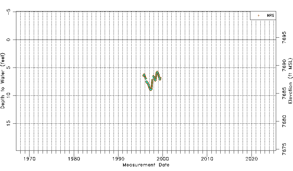
| Water-level Count | 6283 |
| Water-level Date Range | 09/02/1995 thru 06/23/1999 |
| Monitored within the last 18 months | No, most recently on 06/23/1999 |
| Depth-to-Water Range (ft) | 5.71 to 9.03 |
| Water Table Elevation Range (ft NAVD88) | 7685.57 to 7688.89 |
| Water-Level-Source:Number-of-Measurements | HRS:6283 |