| Well Information Table |
|---|
| Common Well ID | DUNWELL_D3 |
| GSDNP Well Name | WELL_D3 |
| USGS Site Use Information | Unknown |
| USGS Groundwater Use Information | Unknown |
| Data Source(s) | HRS |
| Location Data |
|---|
| Longitude/Latitude (NAD83) | -105.53573067 , 37.72833922 |
| Longitude/Latitude Data Source | HRS Dunes database |
| Easting, Northing RGDSS-NAD83 (US ft) | 240004.47 , 266654.68 |
| Elevation and Depth Data |
|---|
| Ground Elevation (ft NAVD88) | 7956.43 |
| Elevation Data Source | Dunes GRSA data |
| GRSA Dunes Well database (ft NGVD29) | 7952.12 |
| 1/3-Arc Second NED Ground Elevation (ft NAVD88) | 7961.97 |
| 1-Arc Second NED Ground Elevation (ft NAVD88) | 7957.95 |
| SRTM Ground Elevation (ft NAVD88) | 7971.56 |
| Total Depth (ft) | 100.00 |
| Depth to Top of Screen (ft) | 90.0 |
| Depth to Bottom of Screen (ft) | 100.00 |
| Model Layer | 1 |
| Model Layer Source | Dunes Layer |
| Depth of Bottom of Layer 1 | 484 |
| Depth of Bottom of Layer 2 | 948 |
| Depth of Bottom of Layer 3 | 1135 |
| Depth of Bottom of Layer 4 | 1441 |
| Additional Well Information | NONE |
| Aquifer Information |
|---|
| Aquifer Type | Unconfined |
| Aquifer Type Source | GRSA_AQUFR |
| Water-level Database Information |
|---|
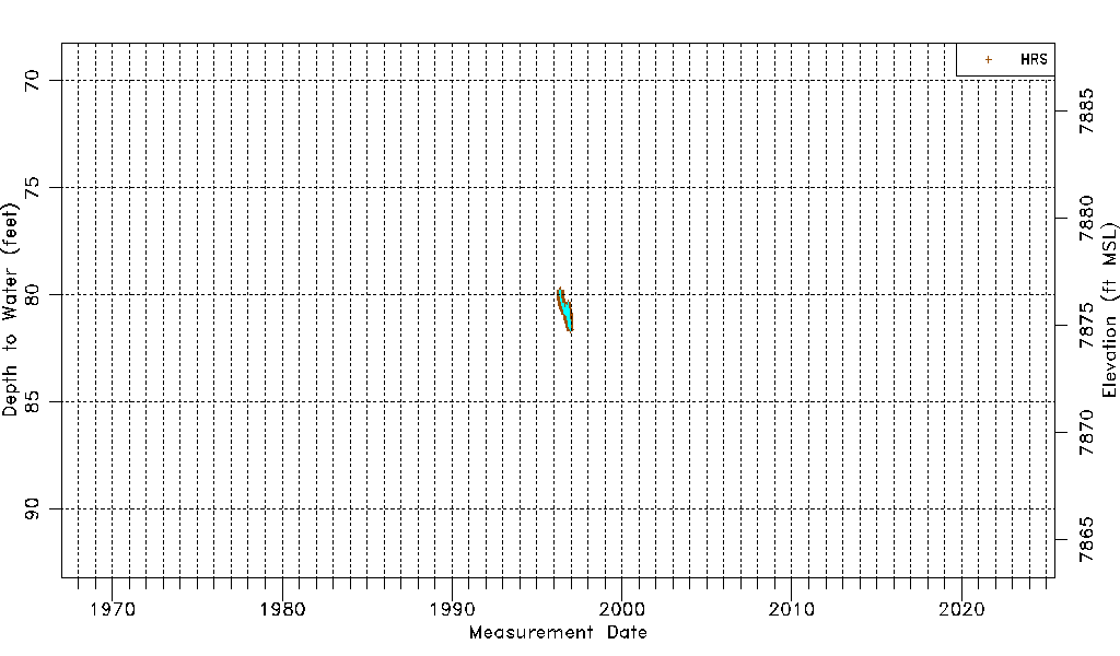
| Water-level Count | 831 |
| Water-level Date Range | 05/02/1996 thru 12/15/1996 |
| Monitored within the last 18 months | No, most recently on 12/15/1996 |
| Depth-to-Water Range (ft) | 79.78 to 81.65 |
| Water Table Elevation Range (ft NAVD88) | 7874.78 to 7876.65 |
| Water-Level-Source:Number-of-Measurements | HRS:831 |