| Well Information Table |
|---|
| Common Well ID | DUNWELL_M |
| GSDNP Well Name | WELL_M |
| USGS Site Use Information | Unknown |
| USGS Groundwater Use Information | Unknown |
| Data Source(s) | HRS |
| Location Data |
|---|
| Longitude/Latitude (NAD83) | -105.52596603 , 37.73722518 |
| Longitude/Latitude Data Source | HRS Dunes database |
| Easting, Northing RGDSS-NAD83 (US ft) | 242822.71 , 269893.34 |
| Elevation and Depth Data |
|---|
| Ground Elevation (ft NAVD88) | 8027.98 |
| Elevation Data Source | Dunes GRSA data |
| GRSA Dunes Well database (ft NGVD29) | 8023.62 |
| 1/3-Arc Second NED Ground Elevation (ft NAVD88) | 8038.02 |
| 1-Arc Second NED Ground Elevation (ft NAVD88) | 8027.70 |
| SRTM Ground Elevation (ft NAVD88) | 8041.55 |
| Total Depth (ft) | 14.00 |
| Depth to Top of Screen (ft) | 9.0 |
| Depth to Bottom of Screen (ft) | 14.00 |
| Model Layer | 1 |
| Model Layer Source | Aquifer Type |
| Depth of Bottom of Layer 1 | 510 |
| Depth of Bottom of Layer 2 | 978 |
| Depth of Bottom of Layer 3 | 1142 |
| Depth of Bottom of Layer 4 | 1323 |
| Additional Well Information | NONE |
| Aquifer Information |
|---|
| Aquifer Type | Unconfined |
| Aquifer Type Source | GRSA_AQUFR |
| Water-level Database Information |
|---|
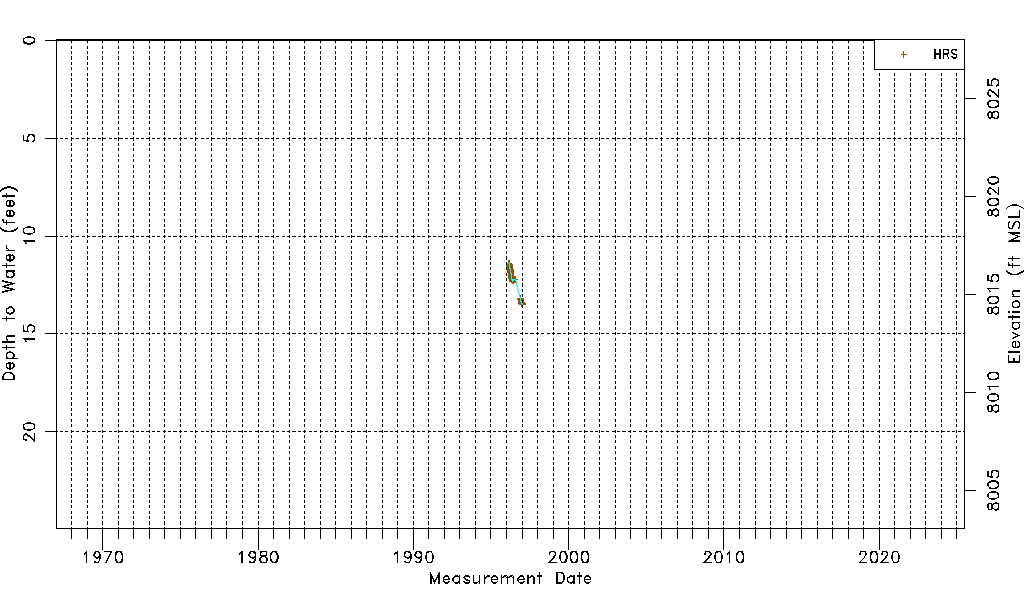
| Water-level Count | 426 |
| Water-level Date Range | 02/28/1996 thru 01/16/1997 |
| Monitored within the last 18 months | No, most recently on 01/16/1997 |
| Depth-to-Water Range (ft) | 11.39 to 13.48 |
| Water Table Elevation Range (ft NAVD88) | 8014.50 to 8016.59 |
| Water-Level-Source:Number-of-Measurements | HRS:426 |