| Well Information Table |
|---|
| Common Well ID | DUNWELL_T |
| GSDNP Well Name | WELL_T |
| USGS Site Use Information | Unknown |
| USGS Groundwater Use Information | Unknown |
| Data Source(s) | HRS |
| Location Data |
|---|
| Longitude/Latitude (NAD83) | -105.64579140 , 37.79240642 |
| Longitude/Latitude Data Source | Davis Engineering Survey |
| Easting, Northing RGDSS-NAD83 (US ft) | 208178.88 , 289950.24 |
| Elevation and Depth Data |
|---|
| Ground Elevation (ft NAVD88) | 7703.38 |
| Elevation Data Source | Davis Engineering Survey |
| GRSA Dunes Well database (ft NGVD29) | 7690.19 |
| 1/3-Arc Second NED Ground Elevation (ft NAVD88) | 7704.38 |
| 1-Arc Second NED Ground Elevation (ft NAVD88) | 7699.70 |
| SRTM Ground Elevation (ft NAVD88) | 7694.56 |
| Total Depth (ft) | 99.00 |
| Depth to Top of Screen (ft) | 94.0 |
| Depth to Bottom of Screen (ft) | 99.00 |
| Model Layer | 1 |
| Model Layer Source | Dunes Layer |
| Depth of Bottom of Layer 1 | 258 |
| Depth of Bottom of Layer 2 | 638 |
| Depth of Bottom of Layer 3 | 1309 |
| Depth of Bottom of Layer 4 | 2594 |
| Additional Well Information | NONE |
| Aquifer Information |
|---|
| Aquifer Type | Unconfined |
| Aquifer Type Source | GRSA_AQUFR |
| Water-level Database Information |
|---|
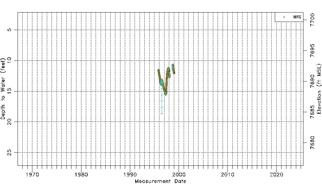
| Water-level Count | 5221 |
| Water-level Date Range | 11/03/1995 thru 01/16/1999 |
| Monitored within the last 18 months | No, most recently on 01/16/1999 |
| Depth-to-Water Range (ft) | 10.62 to 18.63 |
| Water Table Elevation Range (ft NAVD88) | 7684.75 to 7692.76 |
| Water-Level-Source:Number-of-Measurements | HRS:5221 |