| Well Information Table |
|---|
| Common Well ID | DUNWELL_U |
| GSDNP Well Name | WELL_U |
| USGS Site Use Information | Unknown |
| USGS Groundwater Use Information | Unknown |
| Data Source(s) | HRS |
| Location Data |
|---|
| Longitude/Latitude (NAD83) | -105.60721139 , 37.73191243 |
| Longitude/Latitude Data Source | Davis Engineering Survey |
| Easting, Northing RGDSS-NAD83 (US ft) | 219337.38 , 267934.32 |
| Elevation and Depth Data |
|---|
| Ground Elevation (ft NAVD88) | 7707.86 |
| Elevation Data Source | Davis Engineering Survey |
| GRSA Dunes Well database (ft NGVD29) | 7693.76 |
| 1/3-Arc Second NED Ground Elevation (ft NAVD88) | 7718.20 |
| 1-Arc Second NED Ground Elevation (ft NAVD88) | 7708.97 |
| SRTM Ground Elevation (ft NAVD88) | 7695.67 |
| Model Layer | 2 |
| Model Layer Source | Dunes Layer |
| Depth of Bottom of Layer 1 | 278 |
| Depth of Bottom of Layer 2 | 684 |
| Depth of Bottom of Layer 3 | 1268 |
| Depth of Bottom of Layer 4 | 2543 |
| Additional Well Information | NONE |
| Aquifer Information |
|---|
| Aquifer Type | Unconfined |
| Aquifer Type Source | GRSA_AQUFR |
| Water-level Database Information |
|---|
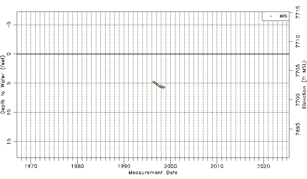
| Water-level Count | 3409 |
| Water-level Date Range | 04/18/1996 thru 09/03/1998 |
| Monitored within the last 18 months | No, most recently on 09/03/1998 |
| Depth-to-Water Range (ft) | 4.75 to 5.75 |
| Water Table Elevation Range (ft NAVD88) | 7702.11 to 7703.11 |
| Water-Level-Source:Number-of-Measurements | HRS:3409 |