| Well Information Table |
|---|
| Common Well ID | DUNWE_W_alice |
| GSDNP Well Name | WE_W_alice |
| USGS Site Use Information | Unknown |
| USGS Groundwater Use Information | Unknown |
| Data Source(s) | HRS |
| Location Data |
|---|
| Longitude/Latitude (NAD83) | -105.63587706 , 37.79202256 |
| Longitude/Latitude Data Source | HRS Dunes database |
| Easting, Northing RGDSS-NAD83 (US ft) | 211042.88 , 289811.28 |
| Elevation and Depth Data |
|---|
| Ground Elevation (ft NAVD88) | 7708.24 |
| Elevation Data Source | HRS Dunes database |
| HRS Dunes Well database (ft NGVD29) | 7704.00000 |
| 1/3-Arc Second NED Ground Elevation (ft NAVD88) | 7707.42 |
| 1-Arc Second NED Ground Elevation (ft NAVD88) | 7701.21 |
| SRTM Ground Elevation (ft NAVD88) | 7698.69 |
| Model Layer | 1 |
| Model Layer Source | Aquifer Type |
| Depth of Bottom of Layer 1 | 263 |
| Depth of Bottom of Layer 2 | 651 |
| Depth of Bottom of Layer 3 | 1264 |
| Depth of Bottom of Layer 4 | 2427 |
| Additional Well Information | NONE |
| Aquifer Information |
|---|
| Aquifer Type | Unconfined |
| Aquifer Type Source | HRS_AQUIFER |
| Water-level Database Information |
|---|
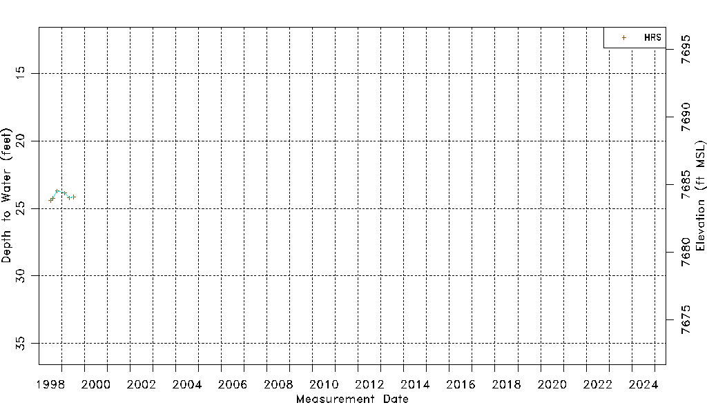
| Water-level Count | 6 |
| Water-level Date Range | 07/12/1998 thru 07/15/1999 |
| Monitored within the last 18 months | No, most recently on 07/15/1999 |
| Depth-to-Water Range (ft) | 23.72 to 24.41 |
| Water Table Elevation Range (ft NAVD88) | 7683.83 to 7684.52 |
| Water-Level-Source:Number-of-Measurements | HRS:6 |