| Well Information Table |
|---|
| Common Well ID | DUNWNSW1 |
| GSDNP Well Name | WNSW-1 |
| USGS Site Use Information | Unknown |
| USGS Groundwater Use Information | Unknown |
| Data Source(s) | HRS |
| Location Data |
|---|
| Longitude/Latitude (NAD83) | -105.82643598 , 37.98443493 |
| Longitude/Latitude Data Source | BACA wells reported by Halepaska |
| Halapaska & Assoc. Easting/Northing (CO-S) | 1906080.00000000 , 479981.000000000 |
| Easting, Northing RGDSS-NAD83 (US ft) | 156116.85 , 359893.86 |
| Elevation and Depth Data |
|---|
| Ground Elevation (ft NAVD88) | 7578.27 |
| Elevation Data Source | NED3 data |
| 1/3-Arc Second NED Ground Elevation (ft NAVD88) | 7578.27 |
| 1-Arc Second NED Ground Elevation (ft NAVD88) | 7578.80 |
| SRTM Ground Elevation (ft NAVD88) | 7584.84 |
| Total Depth (ft) | 7.25 |
| Model Layer | 1 |
| Model Layer Source | Aquifer Type |
| Depth of Bottom of Layer 1 | 113 |
| Depth of Bottom of Layer 2 | 317 |
| Depth of Bottom of Layer 3 | 1310 |
| Depth of Bottom of Layer 4 | 4205 |
| Additional Well Information | NONE |
| Aquifer Information |
|---|
| Aquifer Type | Unconfined |
| Aquifer Type Source | HRS_AQUIFER |
| Water-level Database Information |
|---|
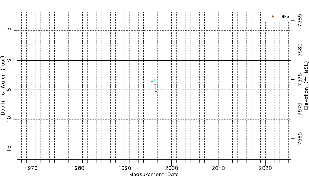
| Water-level Count | 4 |
| Water-level Date Range | 11/07/1995 thru 09/19/1996 |
| Monitored within the last 18 months | No, most recently on 09/19/1996 |
| Depth-to-Water Range (ft) | 3.30 to 5.28 |
| Water Table Elevation Range (ft NAVD88) | 7572.99 to 7574.97 |
| Water-Level-Source:Number-of-Measurements | HRS:4 |