| Well Information Table |
|---|
| Common Well ID | SCS05a |
| USGS Site Use Information | Unknown |
| USGS Groundwater Use Information | Unknown |
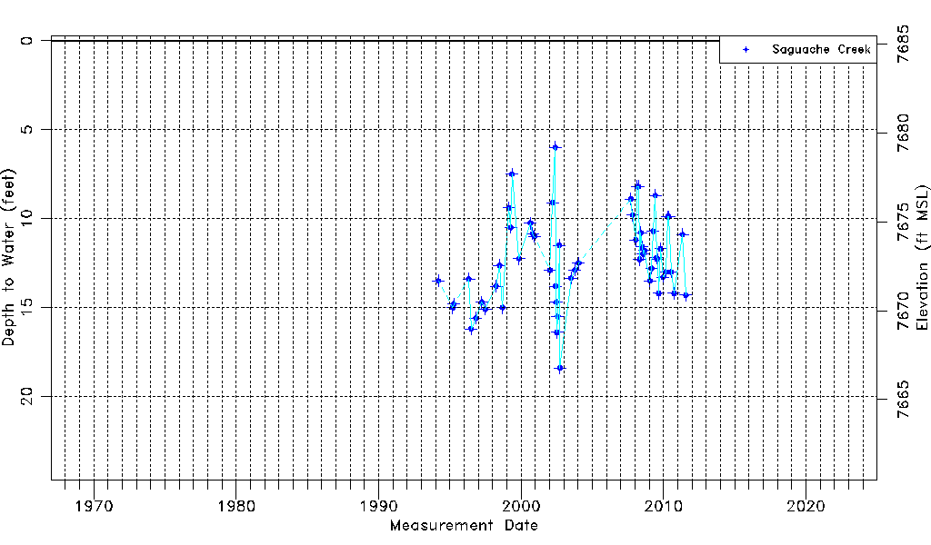
| Data Source(s) | Saguache Creek |
| Location Data |
|---|
| Longitude/Latitude (NAD83) | -106.12483110 , 38.07339309 |
| Longitude/Latitude Data Source | Saguach Ck Survey |
| Easting, Northing RGDSS-NAD83 (US ft) | 70300.20 , 392568.38 |
| Elevation and Depth Data |
|---|
| Ground Elevation (ft NAVD88) | 7685.18 |
| Elevation Data Source | NED3 data |
| 1/3-Arc Second NED Ground Elevation (ft NAVD88) | 7685.18 |
| 1-Arc Second NED Ground Elevation (ft NAVD88) | 7684.47 |
| SRTM Ground Elevation (ft NAVD88) | 7692.58 |
| Model Layer | 1 |
| Model Layer Source | Saguache Layer |
| Depth of Bottom of Layer 1 | 103 |
| Depth of Bottom of Layer 2 | 178 |
| Depth of Bottom of Layer 3 | 278 |
| Additional Well Information | NONE |
| Aquifer Information |
|---|
| Aquifer Type | Unconfined |
| Aquifer Type Source | TD Elevation/Model Layer |
| Water-level Database Information |
|---|
| Water-level Count | 56 |
| Water-level Date Range | 03/15/1994 thru 07/29/2011 |
| Monitored within the last 18 months | No, most recently on 07/29/2011 |
| Depth-to-Water Range (ft) | 6.00 to 18.40 |
| Water Table Elevation Range (ft NAVD88) | 7666.78 to 7679.18 |
| Water-Level-Source:Number-of-Measurements | Saguache Creek:56 |