| Well Information Table |
|---|
| Common Well ID | SCS07 |
| USGS Site Use Information | Unknown |
| USGS Groundwater Use Information | Unknown |
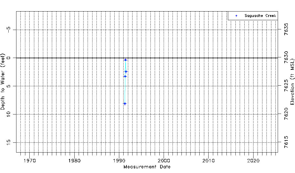
| Data Source(s) | Saguache Creek |
| Location Data |
|---|
| Longitude/Latitude (NAD83) | -106.07252409 , 38.05856923 |
| Longitude/Latitude Data Source | Saguach Ck Survey |
| Easting, Northing RGDSS-NAD83 (US ft) | 85329.82 , 387100.87 |
| Elevation and Depth Data |
|---|
| Ground Elevation (ft NAVD88) | 7629.90 |
| Elevation Data Source | Saguache Creek survey |
| 1/3-Arc Second NED Ground Elevation (ft NAVD88) | 7631.69 |
| 1-Arc Second NED Ground Elevation (ft NAVD88) | 7631.86 |
| SRTM Ground Elevation (ft NAVD88) | 7638.29 |
| Model Layer | 1 |
| Model Layer Source | Saguache Layer |
| Depth of Bottom of Layer 1 | 118 |
| Depth of Bottom of Layer 2 | 220 |
| Depth of Bottom of Layer 3 | 587 |
| Depth of Bottom of Layer 4 | 1057 |
| Additional Well Information | NONE |
| Aquifer Information |
|---|
| Aquifer Type | Unconfined |
| Aquifer Type Source | TD Elevation/Model Layer |
| Water-level Database Information |
|---|
| Water-level Count | 4 |
| Water-level Date Range | 04/19/1991 thru 07/15/1991 |
| Monitored within the last 18 months | No, most recently on 07/15/1991 |
| Depth-to-Water Range (ft) | 0.38 to 8.08 |
| Water Table Elevation Range (ft NAVD88) | 7621.82 to 7629.52 |
| Water-Level-Source:Number-of-Measurements | Saguache Creek:4 |