| Well Information Table |
|---|
| Common Well ID | SCS09 |
| USGS Site Use Information | Unknown |
| USGS Groundwater Use Information | Unknown |
| Data Source(s) | Saguache Creek |
| Location Data |
|---|
| Longitude/Latitude (NAD83) | -106.08226360 , 38.06201298 |
| Longitude/Latitude Data Source | Saguach Ck Survey |
| Easting, Northing RGDSS-NAD83 (US ft) | 82531.99 , 388367.12 |
| Elevation and Depth Data |
|---|
| Ground Elevation (ft NAVD88) | 7638.80 |
| Elevation Data Source | Saguache Creek survey |
| 1/3-Arc Second NED Ground Elevation (ft NAVD88) | 7638.97 |
| 1-Arc Second NED Ground Elevation (ft NAVD88) | 7638.69 |
| SRTM Ground Elevation (ft NAVD88) | 7641.56 |
| Model Layer | 1 |
| Model Layer Source | Saguache Layer |
| Depth of Bottom of Layer 1 | 115 |
| Depth of Bottom of Layer 2 | 210 |
| Depth of Bottom of Layer 3 | 425 |
| Depth of Bottom of Layer 4 | 869 |
| Additional Well Information | NONE |
| Aquifer Information |
|---|
| Aquifer Type | Unconfined |
| Aquifer Type Source | TD Elevation/Model Layer |
| Water-level Database Information |
|---|
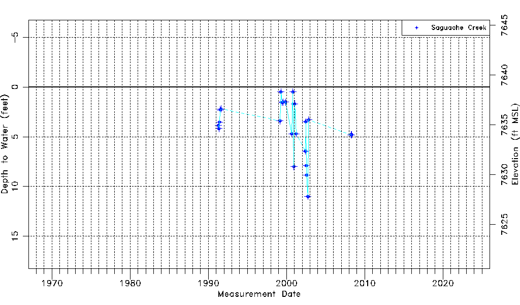
| Water-level Count | 23 |
| Water-level Date Range | 04/16/1991 thru 04/29/2008 |
| Monitored within the last 18 months | No, most recently on 04/29/2008 |
| Depth-to-Water Range (ft) | 0.50 to 11.00 |
| Water Table Elevation Range (ft NAVD88) | 7627.80 to 7638.30 |
| Water-Level-Source:Number-of-Measurements | Saguache Creek:23 |