| Well Information Table |
|---|
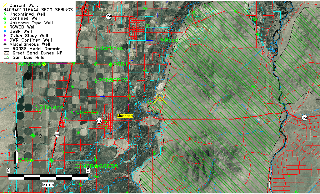
| Common Well ID | NA03401016AAA SEGO SPRINGS |
| USGS Station Name | NA03401016AAA SEGO SPRINGS |
| USGS Site Type | NNNNNYNNNNNNNNNNNNNN |
| USGS Site Use Information | Unknown |
| USGS Groundwater Use Information | Unknown |
| Data Source(s) | USGS |
| Location Data |
|---|
| TRS | NA03401016AAA SEGO SPRINGS |
| USGS TRS 1 | NA03401016AAA SEGO SPRINGS |
| Longitude/Latitude (NAD83) | -105.87418694 , 37.19528917 |
| Longitude/Latitude Data Source | GWSI decimal LAT/LONG field |
| USGS Longitude/Latitude (NAD83) | -105.874186944 , 37.195289167 |
| Easting, Northing RGDSS-NAD83 (US ft) | 141730.67 , 72660.07 |
| USGS Topography | Valley flat |
| USGS County | Conejos County |
| USGS Map Name | MANASSA N.E. |
| Elevation and Depth Data |
|---|
| Ground Elevation (ft NAVD88) | 7653.94 |
| Elevation Data Source | USGS GWSI database |
| USGS Ground Elevation (ft NGVD29) | 7650.00 |
| 1/3-Arc Second NED Ground Elevation (ft NAVD88) | 7656.15 |
| 1-Arc Second NED Ground Elevation (ft NAVD88) | 7648.88 |
| SRTM Ground Elevation (ft NAVD88) | 7651.02 |
| Total Depth (ft) | 575.00 |
| USGS Well Depth (ft) | 575.00 |
| Model Layer | 4 |
| Model Layer Source | Well Depth |
| Depth of Bottom of Layer 1 | 82 |
| Depth of Bottom of Layer 2 | 182 |
| Depth of Bottom of Layer 3 | 355 |
| Depth of Bottom of Layer 4 | 1339 |
| Additional Well Information | Geohydrology, Construction |
| Aquifer Information |
|---|
| Aquifer Type | Confined |
| Aquifer Type Source | TD Elevation/Model Layer |
| USGS Aquifer Type | Confined Single Aquifer |
| USGS Hydrologic Unit | Conejos |
| Water-level Database Information |
|---|
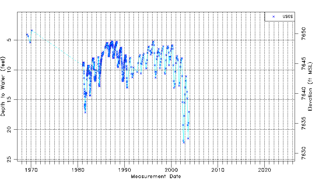
| Water-level Count | 576 |
| Water-level Date Range | 02/19/1969 thru 10/22/2003 |
| Monitored within the last 18 months | No, most recently on 10/22/2003 |
| Depth-to-Water Range (ft) | 3.41 to 22.17 |
| Water Table Elevation Range (ft NAVD88) | 7631.77 to 7650.53 |
| Water-Level-Source:Number-of-Measurements | USGS:576 |