| Well Information Table |
|---|
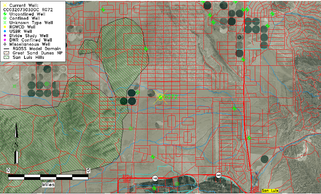
| Common Well ID | CC03207303DDC RG72 |
| RGWCD Well ID | RG72 |
| USGS Well ID | 371642105315101 |
| USGS Station Name | CC03207303DDC RG72 |
| USGS Construction Date | 01/01/1953 |
| USGS Site Type | Well |
| USGS Site Use Information | Unused |
| USGS Groundwater Use Information | Unused |
| Data Source(s) | USGS, RGWCD |
| Location Data |
|---|
| TRS | CC03207303DDC RG72 |
| RGWCD TRS | CC03207303DDC |
| USGS TRS 1 | CC03207303DDC RG72 |
| USGS TRS | SWSESES003T0032SR0073WS |
| Longitude/Latitude (NAD83) | -105.52728333 , 37.28730833 |
| Longitude/Latitude Data Source | RGWCD/Davis Engineering |
| RGWCD Longitude/Latitude (NAD83) | -105:31:38.22 , 37:17:14.31 |
| USGS Longitude/Latitude (NAD83) | -105.527513600 , 37.287789400 |
| Easting, Northing RGDSS-NAD83 (US ft) | 242690.54 , 106125.56 |
| USGS County | Costilla County |
| Elevation and Depth Data |
|---|
| Ground Elevation (ft NAVD88) | 7798.77 |
| Elevation Data Source | RGWCD well database |
| RGWCD Measuring Point Elevation (ft NAVD88) | 7799.120 |
| RGWCD Well Riser Height (ft) | 0.350 |
| RGWCD Ground Surface (ft NAVD88) | 7798.77 |
| USGS Ground Elevation (ft NGVD29) | 7794.00 |
| 1/3-Arc Second NED Ground Elevation (ft NAVD88) | 7797.15 |
| 1-Arc Second NED Ground Elevation (ft NAVD88) | 7798.97 |
| SRTM Ground Elevation (ft NAVD88) | 7804.89 |
| Total Depth (ft) | 415.00 |
| USGS Well Depth (ft) | 415.00 |
| Model Layer | 1 |
| Model Layer Source | RGWCD |
| Depth of Bottom of Layer 1 | 309 |
| Depth of Bottom of Layer 2 | 409 |
| Depth of Bottom of Layer 3 | 776 |
| Depth of Bottom of Layer 4 | 1253 |
| Additional Well Information | Geohydrology, Construction |
| Aquifer Information |
|---|
| Aquifer Type | Unconfined |
| Aquifer Type Source | RGWCD_AQ |
| USGS Primary Aquifer | Cenozoic Erathem |
| USGS Aquifer Type | Unconfined Single Aquifer |
| USGS Hydrologic Unit | Alamosa-Trinchera |
| USGS Data Available | Water-level (GW.LEV) |
| Water-level Database Information |
|---|
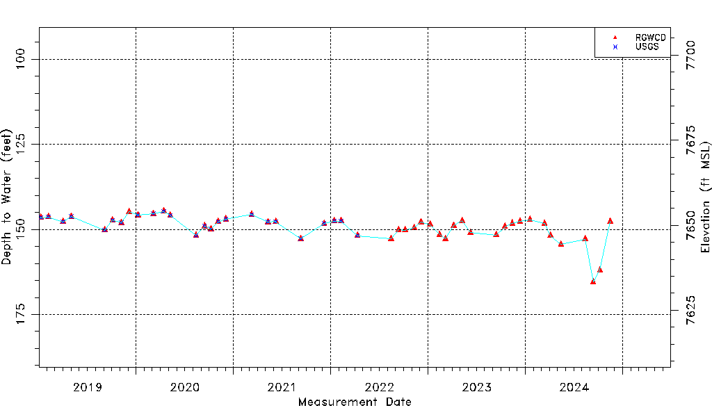
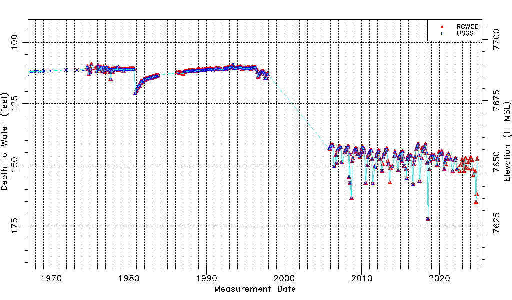
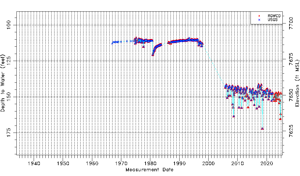
| Water-level Count | 511 |
| Water-level Date Range | 11/28/1966 thru 04/16/2026 |
| Monitored within the last 18 months | Yes, most recently on 04/16/2026 |
| Depth-to-Water Range (ft) | 108.87 to 172.17 |
| Water Table Elevation Range (ft NAVD88) | 7626.60 to 7689.90 |
| Water-Level-Source:Number-of-Measurements | RGWCD:472 USGS:372 |