| Well Information Table |
|---|
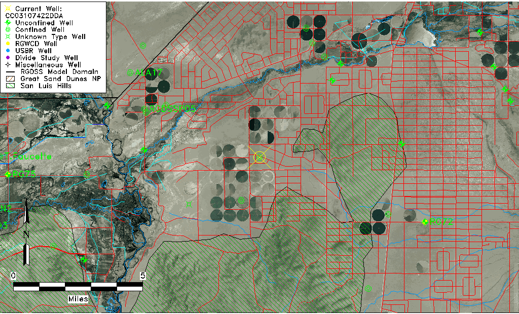
| Common Well ID | CC03107422DDA |
| USGS Well ID | 371925105383401 |
| USGS Station Name | CC03107422DDA |
| USGS Site Type | Well |
| USGS Site Use Information | Withdrawal of Water |
| USGS Groundwater Use Information | Irrigation |
| Data Source(s) | USGS |
| Location Data |
|---|
| TRS | CC03107422DDA |
| USGS TRS 1 | CC03107422DDA |
| USGS TRS | NESESES022T0031SR074WS |
| Longitude/Latitude (NAD83) | -105.64334930 , 37.32362099 |
| Longitude/Latitude Data Source | GWSI decimal LAT/LONG field |
| USGS Longitude/Latitude (NAD83) | -105.643349300 , 37.323620990 |
| Easting, Northing RGDSS-NAD83 (US ft) | 208931.68 , 119311.39 |
| USGS Topography | Valley flat |
| USGS County | Costilla County |
| Elevation and Depth Data |
|---|
| Ground Elevation (ft NAVD88) | 7620.14 |
| Elevation Data Source | USGS GWSI database |
| USGS Ground Elevation (ft NGVD29) | 7616.00 |
| 1/3-Arc Second NED Ground Elevation (ft NAVD88) | 7631.26 |
| 1-Arc Second NED Ground Elevation (ft NAVD88) | 7628.05 |
| SRTM Ground Elevation (ft NAVD88) | 7631.23 |
| Total Depth (ft) | 142.00 |
| USGS Well Depth (ft) | 142.00 |
| Model Layer | 2 |
| Model Layer Source | Well Depth |
| Depth of Bottom of Layer 1 | 133 |
| Depth of Bottom of Layer 2 | 233 |
| Depth of Bottom of Layer 3 | 572 |
| Depth of Bottom of Layer 4 | 1630 |
| Additional Well Information | Geohydrology, Construction |
| Aquifer Information |
|---|
| Aquifer Type | Confined |
| Aquifer Type Source | TD Elevation/Model Layer |
| USGS Primary Aquifer | Cenozoic Erathem |
| USGS Hydrologic Unit | Alamosa-Trinchera |
| USGS Data Available | Water-level (GW.LEV) |
| Water-level Database Information |
|---|
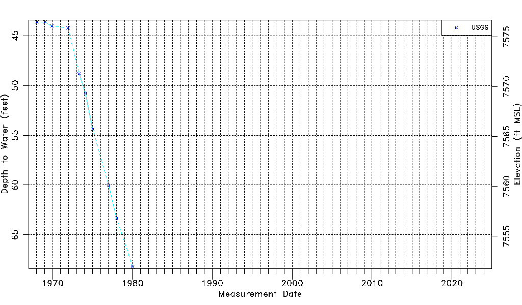
| Water-level Count | 10 |
| Water-level Date Range | 01/16/1968 thru 01/15/1980 |
| Monitored within the last 18 months | No, most recently on 01/15/1980 |
| Depth-to-Water Range (ft) | 43.61 to 68.20 |
| Water Table Elevation Range (ft NAVD88) | 7551.94 to 7576.53 |
| Water-Level-Source:Number-of-Measurements | USGS:10 |