| Well Information Table |
|---|
| Common Well ID | NA03901132CCC |
| USGS Well ID | 373400105481501 |
| USGS Station Name | NA03901132CCC |
| USGS Construction Date | 01/01/1967 |
| USGS Site Type | Well |
| USGS Site Use Information | Observation |
| USGS Groundwater Use Information | Unused |
| Data Source(s) | USGS |
| Location Data |
|---|
| TRS | NA03901132CCC |
| USGS TRS 1 | NA03901132CCC |
| USGS TRS | SWSWSWS032T0039NR0011EN |
| Longitude/Latitude (NAD83) | -105.80224200 , 37.57583635 |
| Longitude/Latitude Data Source | GWSI decimal LAT/LONG field |
| USGS Longitude/Latitude (NAD83) | -105.802242000 , 37.575836350 |
| Easting, Northing RGDSS-NAD83 (US ft) | 162871.21 , 211142.99 |
| USGS Topography | Valley flat |
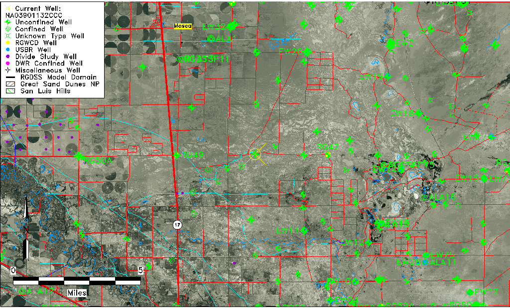
| USGS County | Alamosa County |
| USGS Map Name | HOOPER SE |
| USGS Map Scale | 24000 |
| Elevation and Depth Data |
|---|
| Ground Elevation (ft NAVD88) | 7535.84 |
| Elevation Data Source | USGS GWSI database |
| USGS Ground Elevation (ft NGVD29) | 7532.00 |
| 1/3-Arc Second NED Ground Elevation (ft NAVD88) | 7535.46 |
| 1-Arc Second NED Ground Elevation (ft NAVD88) | 7536.93 |
| SRTM Ground Elevation (ft NAVD88) | 7542.62 |
| Total Depth (ft) | 21.00 |
| USGS Well Depth (ft) | 21.00 |
| Model Layer | 1 |
| Model Layer Source | Well Depth |
| Depth of Bottom of Layer 1 | 46 |
| Depth of Bottom of Layer 2 | 562 |
| Depth of Bottom of Layer 3 | 999 |
| Depth of Bottom of Layer 4 | 2564 |
| Additional Well Information | Geohydrology, Construction |
| Aquifer Information |
|---|
| Aquifer Type | Unconfined |
| Aquifer Type Source | TD Elevation/Model Layer |
| USGS Primary Aquifer | Cenozoic Erathem |
| USGS Hydrologic Unit | San Luis |
| USGS Data Available | Water-level (GW.LEV) |
| Water-level Database Information |
|---|
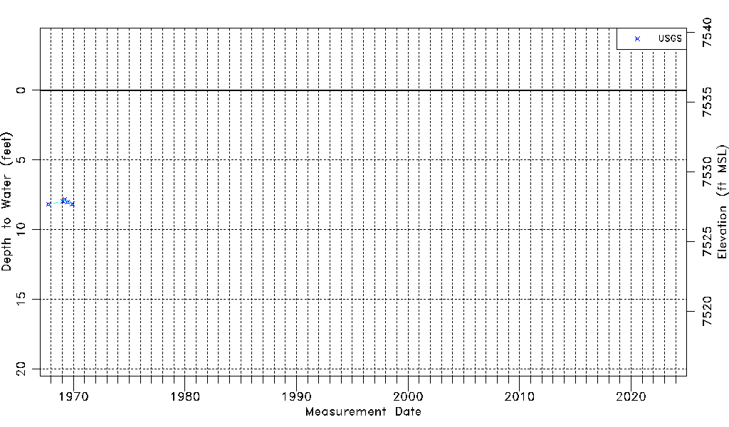
| Water-level Count | 5 |
| Water-level Date Range | 10/04/1967 thru 11/28/1969 |
| Monitored within the last 18 months | No, most recently on 11/28/1969 |
| Depth-to-Water Range (ft) | 7.85 to 8.17 |
| Water Table Elevation Range (ft NAVD88) | 7527.67 to 7527.99 |
| Water-Level-Source:Number-of-Measurements | USGS:5 |