| Well Information Table |
|---|
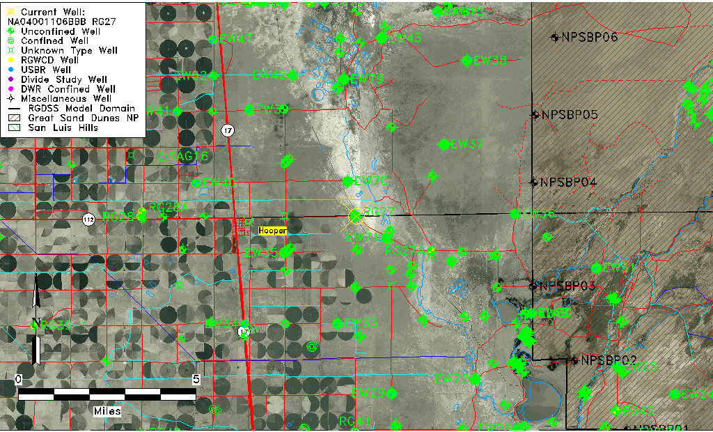
| Common Well ID | NA04001106BBB RG27 |
| RGWCD Well ID | RG27 |
| USGS Well ID | 374501105490301 |
| GSDNP Well Name | 374501105490301 |
| USGS Station Name | NA04001106BBB RG27 |
| USGS Site Type | Well |
| USGS Site Use Information | Observation |
| USGS Groundwater Use Information | Unused |
| Data Source(s) | USGS, RGWCD |
| Location Data |
|---|
| TRS | NA04001106BBB RG27 |
| RGWCD TRS | NA04001106BBB |
| USGS TRS 1 | NA04001106BBB RG27 |
| USGS TRS | NWNWNWS006T0040NR0011EN |
| Longitude/Latitude (NAD83) | -105.81807531 , 37.75027746 |
| Longitude/Latitude Data Source | RGWCD/Davis Engineering |
| RGWCD Longitude/Latitude (NAD27) | -105:49:03 , 37:45:01 |
| USGS Longitude/Latitude (NAD83) | -105.818075300 , 37.750277460 |
| Easting, Northing RGDSS-NAD83 (US ft) | 158385.77 , 274649.45 |
| USGS Topography | Valley flat |
| USGS County | Alamosa County |
| Elevation and Depth Data |
|---|
| Ground Elevation (ft NAVD88) | 7536.91 |
| Elevation Data Source | RGWCD well database |
| RGWCD Measuring Point Elevation (ft NGVD29) | 7534.900 |
| RGWCD Well Riser Height (ft) | 1.900 |
| RGWCD Ground Surface (ft NGVD29) | 7533.00 |
| USGS Ground Elevation (ft NGVD29) | 7533.00 |
| 1/3-Arc Second NED Ground Elevation (ft NAVD88) | 7536.36 |
| 1-Arc Second NED Ground Elevation (ft NAVD88) | 7536.04 |
| SRTM Ground Elevation (ft NAVD88) | 7539.60 |
| Model Layer | 1 |
| Model Layer Source | RGWCD |
| Depth of Bottom of Layer 1 | 100 |
| Depth of Bottom of Layer 2 | 287 |
| Depth of Bottom of Layer 3 | 1488 |
| Depth of Bottom of Layer 4 | 2679 |
| Additional Well Information | Geohydrology, Construction |
| Aquifer Information |
|---|
| Aquifer Type | Unconfined |
| Aquifer Type Source | RGWCD_AQ |
| USGS Primary Aquifer | Cenozoic Erathem |
| USGS Hydrologic Unit | San Luis |
| USGS Data Available | Water-level (GW.LEV) |
| Water-level Database Information |
|---|
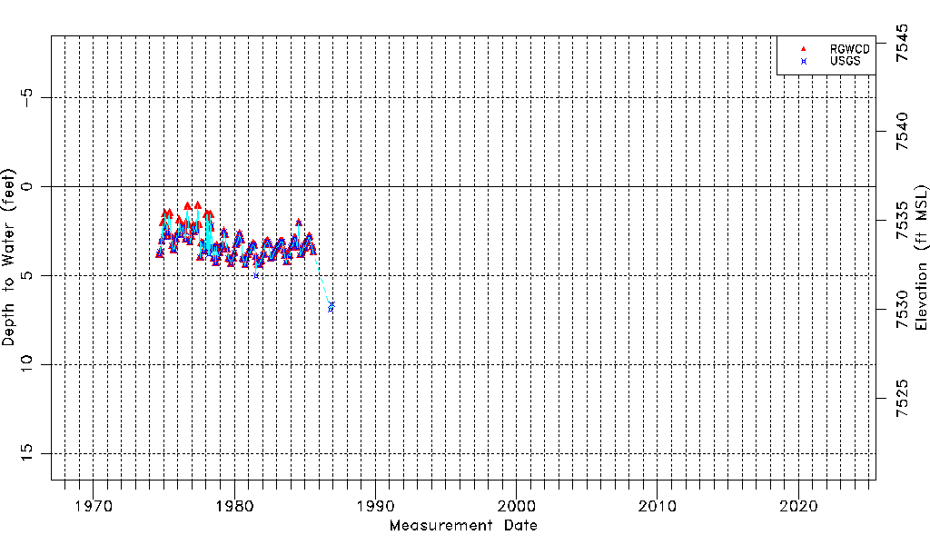
| Water-level Count | 148 |
| Water-level Date Range | 09/05/1974 thru 12/01/1986 |
| Monitored within the last 18 months | No, most recently on 12/01/1986 |
| Depth-to-Water Range (ft) | 1.08 to 6.92 |
| Water Table Elevation Range (ft NAVD88) | 7529.99 to 7535.83 |
| Water-Level-Source:Number-of-Measurements | RGWCD:130 USGS:125 |