| Well Information Table |
|---|
| Common Well ID | NA04501009ABB1 |
| USGS Station Name | NA04501009ABB1 |
| USGS Construction Date | 11/18/1975 |
| USGS Site Type | NNNNNYNNNNNNNNNNNNNN |
| USGS Site Use Information | Unknown |
| USGS Groundwater Use Information | Unknown |
| Data Source(s) | USGS |
| Location Data |
|---|
| TRS | NA04501009ABB1 |
| USGS TRS 1 | NA04501009ABB1 |
| USGS TRS | NWNWNES009T0045NR0010EN |
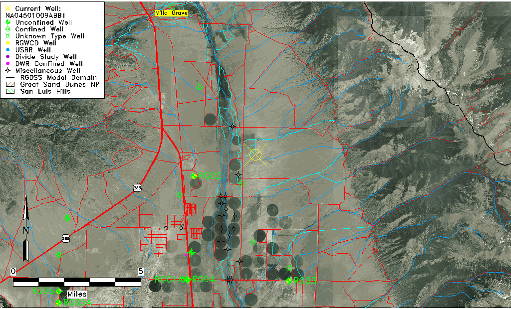
| Longitude/Latitude (NAD83) | -105.87251194 , 38.17166556 |
| Longitude/Latitude Data Source | GWSI decimal LAT/LONG field |
| USGS Longitude/Latitude (NAD83) | -105.872511944 , 38.171665556 |
| Easting, Northing RGDSS-NAD83 (US ft) | 142995.78 , 428080.91 |
| USGS Topography | Valley flat |
| USGS County | Saguache County |
| USGS Map Name | VALLEY VIEW HOT SPRS |
| USGS Map Scale | 24000 |
| Elevation and Depth Data |
|---|
| Ground Elevation (ft NAVD88) | 7799.54 |
| Elevation Data Source | USGS GWSI database |
| USGS Ground Elevation (ft NGVD29) | 7795.00 |
| 1/3-Arc Second NED Ground Elevation (ft NAVD88) | 7799.91 |
| 1-Arc Second NED Ground Elevation (ft NAVD88) | 7802.79 |
| SRTM Ground Elevation (ft NAVD88) | 7808.26 |
| Total Depth (ft) | 540.00 |
| USGS Hole Depth (ft) | 540.00 |
| USGS Well Depth (ft) | 540.00 |
| Model Layer | 4 |
| Model Layer Source | Well Depth |
| Depth of Bottom of Layer 1 | 139 |
| Depth of Bottom of Layer 2 | 160 |
| Depth of Bottom of Layer 3 | 444 |
| Depth of Bottom of Layer 4 | 3100 |
| Additional Well Information | Production, Logs, Geohydrology, Construction, Aquifer |
| Aquifer Information |
|---|
| Aquifer Type | Confined |
| Aquifer Type Source | TD Elevation/Model Layer |
| USGS Hydrologic Unit | San Luis |
| Water-level Database Information |
|---|
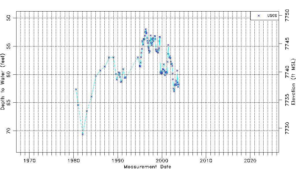
| Water-level Count | 123 |
| Water-level Date Range | 07/14/1980 thru 10/15/2003 |
| Monitored within the last 18 months | No, most recently on 10/15/2003 |
| Depth-to-Water Range (ft) | 52.00 to 70.62 |
| Water Table Elevation Range (ft NAVD88) | 7728.92 to 7747.54 |
| Water-Level-Source:Number-of-Measurements | USGS:123 |